
What is recorded here
From the National Monuments Service (Archaeological Survey of Ireland) record CO006-096003
Places near here
Photo credits
- Maker not stated on source page, www.kpler.com
- Maker not stated on source page, www.pinterest.com
- Maker not stated on source page, tr.pinterest.com
- Maker not stated on source page, www.joinmychurch.com
- Mike Searle, Wikimedia Commons · CC BY-SA 2.0
- National Inventory of Architectural Heritage
- Maker not stated on source page, www.orkneyology.com
- Kmcnamee, Wikimedia Commons · CC BY-SA 4.0
- Unknown author Unknown author, Wikimedia Commons · Public domain
- Maker not stated on source page, en.wikipedia.org
 Standing stone in KnawhillStanding stone · 620 yd
Explorer Tom Standing stone in Knawhill, County Cork is broken down to about one foot high by seven-foot girth. That’s quite a squat…
 Anomalous stone group in Glenfield NorthAnomalous stone group · 1281 yd
Explorer Tom Anomalous stone group in Glenfield North used to be a circle on Mr Cronin's land. Now? The stones are gone. Exact…
 Church in Killinane (duhallow By., Knocktemple Par.)Church · 1.6 mi
Explorer Tom Church in Killinane in County Cork swears there is a tunnel running straight under the field to the local pub, but…
 Church in Kilberrihert (duhallow By.)Church · 1.6 mi
Explorer Tom Church in Kilberrihert is inside a ringfort and has no visible trace, just local rumors calling it 'The Cill'. The…
 Liscarroll Castle (in Ruins)Castle, Anglo-Norman masonry castle · 1.9 mi
Explorer Tom Liscarroll Castle is built by Barrys in the 13th century and looks like it's posing for a photo. The SE tower is…
Liscarroll CastleCastle · 1.9 miExplorer Tom Liscarroll Castle in County Cork was besieged in 1642 and lost parts of its wall to Cromwell, so it has seen some real…
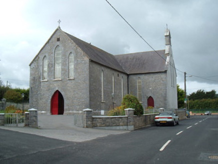 Saint Joseph's ChurchChurch/chapel · 2.0 mi
Explorer Tom Saint Joseph's Church is the first thing you see entering Liscarroll, so it really makes an entrance. The Gothic…
 Standing stone in Coolbane (duhallow By., Knocktemple Par.)Standing stone · 2.0 mi
Explorer Tom Standing stone in Coolbane was recorded by Bowman back in 1934, but folks say this dallan vanished many years ago. Its…
 Freemount GAA pitchGAA ground · 2.0 mi
 Battle of LiscarrollMajor battlefield · 2.0 mi
Explorer Tom Battle of Liscarroll in County Cork is where two armies had a massive row in 1642, and honestly, I think they just…
Liscarroll GAA pitchGAA ground · 2.1 mi Fairy fort / earthen ringfort in LiscarrollFairy fort / earthen ringfort · 2.2 mi
Explorer Tom Fairy fort / earthen ringfort in Liscarroll looks like it's been eaten by grass and time. The bank is barely visible…
More historic places in County Cork · All of County Cork

What do you know about this place?Tap to add a comment or ask a question