
Places near here
Photo credits
- National Inventory of Architectural Heritage
- Rryswny, Wikimedia Commons · CC BY-SA 4.0
- Andreas F. Borchert, Wikimedia Commons · CC BY-SA 4.0
- Graham Horn, Geograph · CC BY-SA 2.0
- Ingo Mehling, Wikimedia Commons · CC BY-SA 3.0
- Stephan van Helden, Wikimedia Commons · CC BY-SA 4.0
- Mike Searle, Wikimedia Commons · CC BY-SA 2.0
- Malene Thyssen, Wikimedia Commons · CC BY-SA 3.0
- DeeEmm, Wikimedia Commons · CC BY-SA 2.0
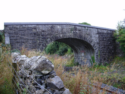 Farranablake BridgeBridge · 664 yd
Explorer Tom Farranablake Bridge in Turloughalanger is refusing to collapse because it’s too proud to admit it’s tired. The limestone looks like it was carved by a very confident mason who loved his job. It’s the perfect spot for a big stretch before we keep moving.
 RockmoreHouse · 784 yd
Explorer Tom Rockmore in Farranablake West is showing off its pilasters like it's a Roman emperor on holiday. The builder definitely thought he was Cleopatra’s cousin, but mostly just built a fancy box with sash windows. Bring your worst joke to match its architectural ego.
 IndicatedTown defences · 1472 yd
Explorer Tom Town defences in Athenry are just the bones of what used to keep people out or in. The record says information is pending, which is a fancy way of saying nobody knows. Linger, it's not going anywhere and neither should you.
 Athenry AbbeyHeritage attraction · 1572 yd
 Check mapCross, Market cross · 1661 yd
Explorer Tom Check map in Athenry is actually a late fifteenth-century market cross in the town square. It’s been watching people haggle for centuries while pretending it doesn’t care about prices. Pretend it's yours and plan the housewarming party with local vendors.
 Athenry CastleHeritage attraction · 1.0 mi
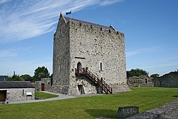 Castle or King Johns Court (in ruins)Castle, Anglo-Norman masonry castle · 1.0 mi
Explorer Tom Castle or King Johns Court in Athenry, County Galway was built by Meiler de Bermingham around 1235, but I suspect King John just used it for his afternoon tea. It controls a ford over the River Clareen. Bring the dog, it'll have opinions.
 Horse-chestnut1.2 miFirst Battle of AthenryBattle · 1.7 mi
Explorer Tom The First Battle of Athenry involved a cow that tried to buy its way out with milk. History is mostly made up by people who were hungry. Pick a stone, any stone, and invent its biography.
 Moyode CastleCastle · 2.8 mi
 European Beech8.5 mi
 Knocktuagh alias Knockdoe ...Battlefield · 8.8 mi
More archaeology and monuments in County Galway · All of County Galway

What do you know about this place?Tap to add a comment or ask a question