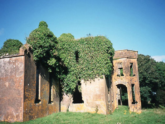
What is recorded here
Castlequin had a private chapel in its east wing, taking all the hardship out of repentance. You could disgrace yourself at dinner and be forgiven before anyone cleared the pudding.
Detached seven-bay two-storey house, built c. 1840, incorporating fabric of earlier building to north. Comprising three-bay two-storey projecting bay to centre on a half-octagonal plan with two-bay double-height gable-fronted recessed end bays to east and to west. Two-bay side elevations. End bay to east originally in use as private chapel. Five-bay rear elevation to north having two-bay two-storey return with single-bay two-storey block at right angles to north. In use, pre-1934, now ruinous. Rendered rubble stone walls with parapet wall to projecting bay. Flat-headed openings with timber lintels, lead trays below two first floors, sills now removed. Facetted central two-storey bay to facade apparently with doors to each side. East doorway with outline of pediment over west doorway with plinth. Detached five-bay two-storey rubble stone-built outbuilding, built c. 1840, to north-west, now derelict. Detached five-bay two-storey rubble stone-built outbuilding, built c. 1840, to north-west with round-headed integral carriage arch and single-bay single-storey lean-to projecting bay to centre, now ruinous. Detached eight-bay two-storey rubble stone-built outbuilding, built c. 1840, to north-west with lancet arch openings, now ruinous. Remains of rubble stone-built walled garden, built c. 1840. Gateway, built c. 1840, to south-east comprising pair of cast-iron piers with cast-iron gates.
From the Buildings of Ireland (National Inventory of Architectural Heritage) record 21307903
This does not grant access. Most recorded buildings are privately owned; view them only from public ground unless the owner allows entry.
Places near here
Photo credits
- Donal.hunt, Wikimedia Commons · CC BY-SA 4.0
- Mat Tuck, Wikimedia Commons · CC BY-SA 2.0
- Russel Wills, Wikimedia Commons · CC BY-SA 2.0
- Theboykenny, Wikimedia Commons · CC BY-SA 4.0
- Michael G Kenny, Wikimedia Commons · CC BY-SA 4.0
- Roger Diel, Geograph · CC BY-SA 2.0
- JoachimKohlerBremen, Wikimedia Commons · CC BY-SA 4.0
- Linda Bailey, Wikimedia Commons · CC BY-SA 2.0
- Kieran Evans, Geograph · CC BY-SA 2.0
- Peigios, Wikimedia Commons · CC BY-SA 4.0
- Neville Goodman, Geograph · CC BY-SA 2.0
- Adrian Beney, Geograph · CC BY-SA 2.0
 Killobarnaun Oratory (in ruins)Church · 1058 yd
 Valencia River ViaductBridge · 1330 yd
 Cahergal Ring FortArchaeological place · 1514 yd
 CahergalFairy fort / stone ringfort · 1519 yd
 Ballycarbery CastleRuins · 1.1 mi
 OutlinedBawn · 1.1 mi
 Ballycarbery Castle (in ruins)Castle, hall-house · 1.1 mi
 BenteeMountain / peak · 1.9 mi
 White Strand BeachBeach / strand · 1.9 mi
 Church IslandIslet · 2.4 mi
 Laharn Bog LoopWalking route · 2.4 mi
 Killelan MountainMountain / peak · 2.9 mi
More historic places in County Kerry · All of County Kerry
What do you know about this place?