What is recorded here
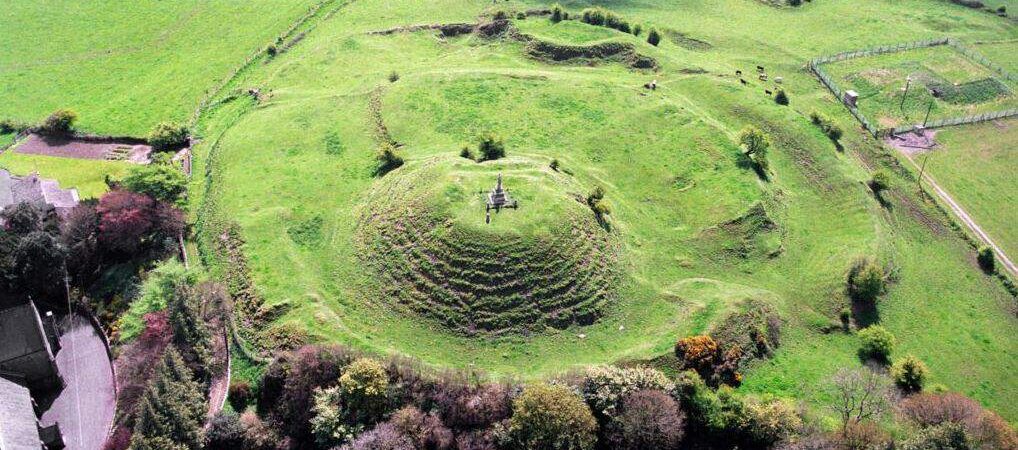
Situated in a level landscape, c. 100m NNW of the site of the medieval parish church of Laracor (ME036-044----). This is a grass-covered, circular, and round-topped mound (diam. of base 20m; H 4m) with a stone-revetted ledge around the base that supports some mature deciduous trees. Its domed summit has led to it being classified as a barrow (Moore 1987, 30) but archaeological testing (04E0987) identified a fosse (Wth c. 5m) immediately around it, which could support either classification, but it was not excavated (Breen 2010, 4). The mound is located at the NW edge of a bivallate enclosure or rath (ME036-043001-) the two ditches of which were tested (Breen 2007), but the relationship between the mound and the enclosure ditches was not completely resolved. However, as the mound is within the area of the rath it is likely to be a motte (Breen 2010, 42-3) that was established after the rath was defunct, and was probably built as part of the medieval settlement around the church.
The above description is derived from the published 'Archaeological Inventory of County Meath' (Dublin: Stationery Office, 1987). In certain instances the entries have been revised and updated in the light of recent research.
Date of revision: 9 November 2017
Built in the 12th century, likely by a local Norman lord following the Anglo-Norman invasion of Ireland, the motte at Laracor is important as a surviving example of early medieval military architecture in the region. Its association with the nearby medieval parish church highlights its role in the establishment of Norman authority and settlement in the area.
The monument record does not grant public access. Check the route and ask the landowner before entering private land.
- What survives
- Recorded monument
Places near here
 Font in LaracorFont · 113 yd
 IndicatedBridge · 164 yd
 Enclosure in Stokestown (moyfenrath Lwr By)Enclosure · 1365 yd
 Fosterstown Housecountry house · 1.1 mi
 Trim CastleCastle, Anglo-Norman masonry castle · 1.9 mi
 Saints IslandForest · 2.0 mi
 Dangan CastleCastle, tower house · 2.0 mi
 European ashEuropean ash · 3.4 mi
 Kilgar GardensHeritage attraction · 7.3 mi
 Old Bog Road made famous by Teresa Bryton 1868-1943Memorial · 7.4 mi
 Cloncurry GraveyardHeritage attraction · 7.7 mi
 Candle HillMountain / peak · 11 mi
Other information
Photo: Credit not shown in the picture search · Rights wording not checked; contact us if this picture should be removed