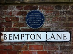
What is recorded here
This blue commemorative plaque records: The historic name for this road was Carter Lane. It runs 400 yds north then 225 yds east and terminates at Prospect House
A plaque record does not grant entry to a building or private land. View it from a public place unless permission is clearly given.
Places near here
 Carr FarmhouseListed building · 55 yd
 Church of St OswaldListed building · 82 yd
 The fishermen's monument, FlamboroughMonument or public art · 342 yd
 The Coble Two Brothers monumentMonument or public art · 452 yd
 Maidlands PlantationWood · 766 yd
 Needles PlantationWood · 816 yd
 Living Seas CentreHeritage attraction · 899 yd
 Donkey and Baskets SculpturePublic sculpture · 1140 yd
 South SeaBay · 1410 yd
 Flamborough HeadVisitor information · 1511 yd
 Thornwick BayBeach / strand · 1.4 mi
 Little Thornwick BayBeach / strand · 1.4 mi
Other information
Photo: Jez Nicholson · CC BY-SA 2.0