
Places near here
Photo credits
- Colin Park, Geograph · CC BY-SA 2.0
- National Inventory of Architectural Heritage
- Colin Park, Wikimedia Commons · CC BY-SA 2.0
- Espresso Addict, Wikimedia Commons · CC BY-SA 2.0
- Pam Brophy, Wikimedia Commons · CC BY-SA 2.0
- Gareth James, Wikimedia Commons · CC BY-SA 2.0
- Graham Horn, Geograph · CC BY-SA 2.0
- Neville Goodman, Geograph · CC BY-SA 2.0
- Vadim Manuylov, Wikimedia Commons · CC BY-SA 3.0
- Mike Searle, Wikimedia Commons · CC BY-SA 2.0
- Peter Gerken, Geograph · CC BY-SA 2.0
 CrohaneMountain / peak · 1560 yd
Explorer Tom Crohane in County Kerry would write on its dating profile that it’s looking for someone who doesn’t mind a bit of grit and great views. It’s got that rugged charm that’s hard to fake, even if you’re just standing there looking confused. Best visited with a curious kid and no timetable.
 bridge1.5 mi
Explorer Tom Bridge in Derreenacullig would date a tractor if it had a phone number and a dating profile. It spent decades carrying trains before switching to cars, so it's got mixed signals about its own identity. Tell the next person you meet it's haunted. It might be.
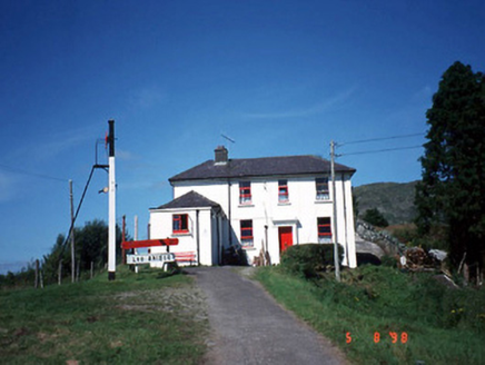 railway station1.5 mi
Explorer Tom Railway station in Derreenacullig is claimed by a local who says he invented the concept of waiting. Opened in 1893, it now serves as a youth hostel for adventurous souls. Bring a notebook and write the bit I made up.
 StoompaMountain / peak · 3.3 mi
Explorer Tom Stoompa is haunted by a ghost who is far too lazy to actually haunt anyone, preferring to nap in the bracken instead. It’s got a real chill vibe, but you’d have to be very still to notice anything spooky. Perfect spot to practise your best tour-guide voice.
 TooreencormickBattlefield · 4.9 mi
Explorer Tom Tooreencormick is playing hard to get, sitting on Mangerton like it’s keeping a secret from everyone. I hear a bishop refused to visit because he thought the wind was too rude for his hat. Grand place for a sulk or a snog, your call.
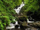 Torc WaterfallWaterfall · 6.0 mi
Explorer Tom If you hear a wild boar at Torc, check whether it is me puffing up the path. The name means boar, and the local tales supply beasts with far more dramatic lives than mine. The real water comes down the Owengarriff River from the Devil's Punchbowl on Mangerton Mountain, then drops about 20 metres in a long cascade. Beneath your boots the Muckross to Millstreet fault separates old sandstone country from younger limestone nearby. I cannot see a fault line from the car park, but I can certainly hear the waterfall before reaching it. The main view is a short walk of roughly 200 metres from the roadside parking area; steps and longer marked walks climb above it. Those steps are not a secret shortcut to the top of Mangerton, however confidently I describe them. Follow the path and let the spray finish my sentence for me.
 Muckross AbbeyVisitor attraction · 6.2 mi
Explorer Tom Muckross Abbey in Kerry gave up meat for Lent but probably snuck some bacon in its windows just to spite the monks who built it all those years ago. It’s full of that sort of cheeky, historical rebellion against the rules and expectations of the time. Stop the car, it's worth the hazard lights.
 Muckross Lake WalkWalking route · 6.2 mi
Explorer Tom Muckross Lake Walk in County Kerry would teach history by making everyone stand in a puddle until they understood the concept of wetness and consequences properly. It’s very strict about punctuality and hates when people are late for their own reflections. Ideal for a moody photo you'll pretend wasn't posed.
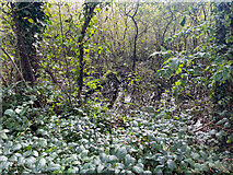 Sheheree Bog Nature ReserveNature reserve · 6.2 mi
Explorer Tom Sheheree Bog Nature Reserve in County Kerry is basically a giant swampy trampoline that nobody maintains. I bet the guy who drew up the map just said 'put a bog there' and went to get a sandwich, leaving us to figure out if it's safe. Linger, it's not going anywhere and neither should you.
 Monterey Cypress6.3 mi
Explorer Tom Monterey Cypress in County Kerry has a massive grudge against the narrow road that leads to it. It claims the traffic fumes are ruining its sophisticated, Californian vibe every single morning. Make up your own legend and I'll swear it's true.
 Flesk CastleCastle · 6.6 mi
Explorer Tom Flesk Castle is arguing with a fairy about who gets the best parking spot. The wind has been picking on its roof for centuries, probably because it looks like it’s trying to fly away. Grand place for a sulk or a snog, your call.
 Castlelough BayBay · 6.8 mi
Explorer Tom Castellough Bay has a bird that refuses to leave no matter how much the wind tries to blow it away, and frankly, I envy its commitment to staying put. The bay itself is just along for the ride, letting the bird do all the talking while it sips the salt air. Bring a map, get lost anyway, that's the fun.
More mountains and hills in County Kerry · All of County Kerry

What do you know about this place?Tap to add a comment or ask a question