
Places near here
Photo credits
- Rossographer, Wikimedia Commons · CC BY-SA 2.0
- National Inventory of Architectural Heritage
- Kenneth Allen, Geograph · CC BY-SA 2.0
- Colin Park, Geograph · Creative Commons Attribution-ShareAlike 2.0
- Wanfried-Dublin, Wikimedia Commons · CC BY-SA 4.0
- Patrice78500, Wikimedia Commons · Public domain
- Colin Park, Wikimedia Commons · CC BY-SA 2.0
- Rossographer, Geograph · CC BY-SA 2.0
- Vadim Manuylov, Wikimedia Commons · CC BY-SA 3.0
- Ronnie Nijboer, Wikimedia Commons · CC0
- Joseph Mischyshyn, Geograph · CC BY-SA 2.0
 Cairn, CronalaghtPublicly named cairn · 1.5 mi
Explorer Tom Cairn, Cronalaght is a place where the name suggests a specific local identity and history. I imagine it’s one of those spots where people have gathered or marked their presence for generations. It’s a name that makes you wonder about the stories behind the stones.
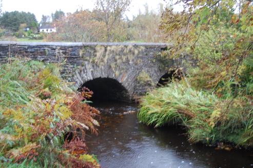 Fawnaboy BridgeBridge · 2.0 mi
Explorer Tom Fawnaboy Bridge crosses the Glenna River on two arches, built around 1810. Triangular cut-waters stand between the spans, while field-stone blocks form the curves. Two rounded arches and sharp points: the stonework changes its geometry halfway across the river.
 An ChuirtHotel · 2.6 mi
Explorer Tom An Chuirt in Gweedore is shaking its head at Storm Desmond’s leftovers right now. It’s proud of surviving that mess without a single curtain flying out. It's the kind of place that makes a dull Tuesday interesting.
 Catholic Church of the Sacred HeartChurch/chapel · 3.1 mi
Explorer Tom Catholic Church of the Sacred Heart stands between Errigal Mountain and Lough Nacung, with a round tower and a purple-and-grey slate roof. Errigal gets a mountain peak; the church answers with a tower and cross. I know which one I would draw first.
 McGeady's BarPub · 3.1 mi
Explorer Tom McGeady’s Bar is sitting there looking suspiciously quiet in County Donegal, waiting for someone to ask if they’ve had any ghosts. Order something strong and blame all the damp on them instead, because that’s just how it works sometimes. Go in good boots and better humour.
 Dermot and Granias Bed (1905).Portal tomb · 3.4 mi
Explorer Tom Take a look at Dermot and Granias Bed (1905), a portal tomb tucked into the garden of a house near Ballyness Bay. Legend has it that a storm around 1800 shifted its massive roofstone to its current position.
 Errigal / An EaragailMountain / peak · 3.7 mi
Explorer Tom Errigal. An Earagail, to be precise. It rises 751 metres above Dunlewey, looking like it’s judging your life choices. It’s the tallest peak in County Donegal and the southernmost of the Seven Sisters. That’s a fancy name for a row of mountains that probably argue about who’s taller. The trail is loose, and the One Man’s Pass is narrow enough to make your knees wobble. The weather here has a mind of its own, so your plans and the clouds might disagree. From below, the white slope is stark and beautiful. Up close, it’s just wind, rock, and you. You’ll see the Derryveagh Mountains stretching out, wild and unbothered. It’s not for the faint-hearted, but it’s worth the wobble. Just don’t tell the other Sisters I called them bossy.
 Aghla MoreMountain / peak · 3.9 mi
Explorer Tom Aghla More is part of a local group called the Seven Sisters. I have to ask if they ever get bored of each other, or if that is just what mountains do when they stand close enough to gossip.
 MagheraroartyOfficial bathing water · 5.0 mi
Explorer Tom Magheraroarty has pulled a fine trick on the map: Atlantic on one side of a sandy spit, Ballyness Bay on the other, Inishbofin up north. That is enough directions for one beach to manage. The western shore takes a strong Atlantic wash, so I would keep my admiration on dry sand.
 Monterey Cypress5.8 mi
Explorer Tom Monterey Cypress in County Donegal is pretending to be from California. It's a bit out of place, like a surfboard in a bog. It wants permission for everything. Tell it to relax and let the wind do its hair.
 Wych Elm5.9 mi
Explorer Tom Wych Elm in County Donegal is getting a bit ratty, as they do, and it's very particular about who can touch it. It might need permission to just be a tree. Tell it to stop shedding so much everywhere, mate.
 The Bridge of TearsMemorial · 6.6 mi
Explorer Tom The Bridge of Tears carried more than traffic through Muckish Gap. Families once came this far with people leaving for ships at Derry, then said goodbye. The Irish words on a stone beside the bridge remember that parting. I would stop for the story, but keep clear of the road.
More mountains and hills in County Donegal · All of County Donegal

What do you know about this place?Tap to add a comment or ask a question