
What is recorded here
Carlingford Lough is a sea lough and mountain landscape in County Louth, Ireland.
Check current access, opening information and local safety conditions before going.
Places near here
 Little MoatBay · 1.2 mi
 Kilbroney ParkVisitor information · 1.5 mi
 Carlingford - Slieve Foye LoopWalking route · 1.8 mi
 Ross MonumentMonument · 1.8 mi
 Ross MonumentMemorial · 1.8 mi
 Carlingford Lough GreenwayWalking route · 1.9 mi
 Presbyterian ChurchChurch · 1.9 mi
 Slieve Foye North-West TopMountain / peak · 1.9 mi
 SlievemartinMountain / peak · 2.0 mi
 King Johns Castle in ruinsCastle, Anglo-Norman masonry castle · 2.1 mi
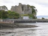 Carlingford CastleHeritage attraction · 2.1 mi
 Dobbin's PointHeadland · 2.3 mi
Pictures: Eric Jones, Geograph · CC BY-SA 2.0; Eric Jones, Wikimedia Commons · CC BY-SA 2.0; jai, Wikimedia Commons · CC BY-SA 2.0
More things to do in County Louth · All of County Louth
What do you know about this place?