
Places near here
Photo credits
- Kenneth Allen, Wikimedia Commons · CC BY-SA 2.0
- Kenneth Allen, Geograph · Creative Commons Attribution-ShareAlike 2.0
- Kenneth Allen, Geograph · CC BY-SA 2.0
- R0025693, Wikimedia Commons · CC BY-SA 4.0
 Clogher Presbyterian ChurchChurch · 722 yd
Explorer Tom Clogher Presbyterian Church is standing there looking all dignified, but if you ask the local sheep, they say the pews are just a glorified scratching post with excellent acoustics. Best enjoyed with a bag of chips and no plans.
 Rath in Carntall MoreRath · 730 yd
Explorer Tom Rath in Carntall More would absolutely nail a job interview by telling you it’s been sitting on that ridge since the dawn of time, yet nobody remembers its actual title. It’s just vibing on the back of an undulating hill like a lazy king who forgot his crown. Wave at the cows, they're the real locals.
 Standing stone: cope's stone in KillyfaddyStanding Stone: Cope's Stone · 838 yd
Explorer Tom Standing stone: cope's stone in Killyfaddy is trying to look mysterious, but honestly, it just looks like a very tall, very confused garden ornament that got lost on its way to a posh estate sale somewhere else entirely. It’s been standing there since before anyone knew what a Tuesday was, so give it some credit for the commitment to the bit, yeah? Bring a jacket, it's never as warm as I promise.
 Pre-norman cathedral; graveyard; augustinian friary; post-med. and modern cathedral; graveyard; 3 crosses; 2 bullauns: clogher cathedral or clochar or CLOCHAR-MAC-nDAIMENI in Clogher DemesnePre-norman Cathedral · 1.4 mi
Explorer Tom Clogher Cathedral would win any county fair because it has more history in one stone than your whole family tree combined. It’s basically a museum that forgot to put on the lights. Take a breath of that air, it's older than your car.
 Protestant HallHall · 1.4 mi
Explorer Tom Protestant Hall in Clogher has a curse that only affects people who don't wave when they walk past because it thinks they’re being rude. It’s a Grade B1 beauty that deserves your full attention and maybe a little bit of respect for its architectural bones. Take the long way round, it deserves the effort.
 C17th fortified house & bawn: aughentaine or aghintain castle in AghintainC17th Fortified House & Bawn: Aughentaine or Aghintain Castle · 1.6 mi
Explorer Tom Aughintain Castle is having a massive identity crisis between being Aghintain and just plain confused. If it walked into a chippy, I bet its last order was double chips with no ketchup because it feels too fancy for that. Stand there long enough and someone will ask if you're lost.
 Aughintain CastleRuins · 1.6 mi
Explorer Tom Aughintain Castle would thrive on a reality show because it knows exactly how to look dramatic when the camera crew arrives. It’s a ruin that performs its crumbling act for an audience of one very bored sheep nearby. Bring someone who'll believe anything.
Knockmany ForestForest · 2.2 miExplorer Tom Knockmany Forest inspired a poet who wrote 'The trees are green, the ground is dirt' before falling asleep in a ditch. It's not exactly high art, but the forest doesn't care about your literary standards. Look for the ghost, then pretend you didn't.
 KnockmanyArchaeological place · 2.5 mi
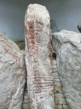
Explorer Tom Knockmany has stone patterns so old I would be foolish to pretend I can read their secret message. The passage tomb near Augher dates to around 3000 BC. Thirteen sandstone uprights remain, and three carry rare carved circles, spirals and zigzags. A protective chamber and mound were built in 1959, so the art can be seen through the entrance gates without putting the stones at risk. The place has later tales of Queen Báine and Fionn mac Cumhaill, but those are stories, not labels left by the builders. I would happily tell one on the walk up and then let the carving hold my tongue. Check current site access, use the path and never touch or mark the stones. Some things have lasted precisely because later visitors learned to leave them alone.
 Multiperiod Church & Graveyard with Carved Stones, Cross & Sheela-na-gig: Errigal Keerogue in GortMultiperiod Church & Graveyard with Carved Stones, Cross & Sheela-na-gig: Errigal Keerogue · 4.8 mi
Explorer Tom Multiperiod Church & Graveyard with Carved Stones, Cross & Sheela-na-gig: Errigal Keerogue in Gort has a least favourite visitor, and honestly, it’s probably anyone wearing flip-flops. The sheela-na-gig statue is just there to judge your outfit while you’re busy taking photos. Have a nosey, politely.
 "Fivemiletown Deli" G8 Virtual ShopHeritage attraction · 5.7 mi
Explorer Tom "Fivemiletown Deli" G8 Virtual Shop is basically a vacant building that has decided to be a deli in its dreams. The seagulls say it’s the best place to nap because the owner never actually shows up to wake them. Have a nosey, politely.
 Sliabh Beagh WayWalking route · 6.1 mi
Explorer Tom Sliabh Beagh Way is stuck in a fairy dispute over who gets to park their little wicker cart on the ridge, causing a total gridlock. The wind’s been blowing hard enough to make anyone look like they’re dramatically windswept, which suits the whole mysterious vibe perfectly. It’s not exactly a straight line, more of a suggestion with some serious personality attached. Perfect place
More walking routes in County Tyrone · All of County Tyrone

What do you know about this place?Tap to add a comment or ask a question