
What is recorded here
Places near here
Photo credits
- Maker not stated on source page, in.pinterest.com
- Billy McCrorie, Wikimedia Commons · CC BY-SA 2.0
- Humphrey Bolton, Wikimedia Commons · CC BY-SA 2.0
- Iain Thompson, Wikimedia Commons · CC BY-SA 2.0
- Richard Webb, Wikimedia Commons · CC BY-SA 2.0
- Chris Newman, Wikimedia Commons · CC BY-SA 2.0
- Colin Kinnear, Wikimedia Commons · CC BY-SA 2.0
- Milestone Society, Wikimedia Commons · CC BY-SA 2.0
- David Neale, Wikimedia Commons · CC BY-SA 2.0
- Leslie Barrie, Wikimedia Commons · CC BY-SA 2.0
 Torthorwald Parish Church, Churchyard and GatepiersBurial Ground (medieval), Church (medieval), Gate Pier (medieval), Grave Slab (medieval) · 865 yd
Explorer Tom Torthorwald Parish Church is playing hard to get, which I love because my least favourite visitor is definitely the…
 TorthorwaldTrack (medieval) · 871 yd
Explorer Tom Torthorwald is a medieval track that seems to have been built on a bargain where both sides lost out, leaving us with…
 Torthorwald, Cruck-framed CottageCruck Framed Cottage (19th Century) · 1028 yd
Explorer Tom Torthorwald Cruck Cottage is so crooked a cow tried to buy it out of sympathy. The frame is basically doing all the…
 Whiteside HillMountain / peak · 1061 yd
 Torthorwald CastleCastle (medieval), Earthwork(s), Motte (medieval) (possible), Tower House (medieval) · 1117 yd
Explorer Tom Torthorwald Castle is a medieval castle with earthworks, a possible motte, and a tower house that would probably…
 North CarthatFarmstead, Mill (possible), Mill Dam · 1.1 mi
Explorer Tom North Carthat in Dumfries and Galloway would introduce itself to a stranger by listing three different jobs at once. I…
 West RoucanFarmstead · 1.2 mi
Explorer Tom West Roucan has a tall tale about a hidden tunnel that goes straight to the local pub, but nobody believes it because…
 Crochmade WoodWood · 1.3 mi
 Ryemuir WoodWood · 1.3 mi
 Hazelshaw HillMountain / peak · 1.9 mi
 War MemorialMemorial · 1.9 mi
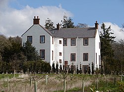 RockhallHotel (17th Century), Tower House (medieval) · 2.2 mi
Explorer Tom Rockhall is a seventeenth-century hotel and medieval tower house that would probably describe itself as 'a charming…
More archaeology and monuments in Dumfries and Galloway · All of Dumfries and Galloway

What do you know about this place?Tap to add a comment or ask a question