
What is recorded here
From the Northern Ireland Sites and Monuments Record record LDY001:008
Places near here
Photo credits
- Rossographer, Geograph · CC BY-SA 2.0
- Maker not stated on source page, www.pinterest.com
- Rossographer, Wikimedia Commons · CC BY-SA 2.0
- Ian Paterson, Wikimedia Commons · CC BY-SA 2.0
- Maker not stated on source page, www.dreamstime.com
- National Inventory of Architectural Heritage
- Maker not stated on source page, jp.pinterest.com
- Kenneth Allen, Geograph · CC BY-SA 2.0
- Albert Bridge, Geograph · CC BY-SA 2.0
 North Base Station, Lough Foyle Base LineMonument · 1.2 mi
Explorer Tom North Base Station, Lough Foyle Base Line in County Derry would explain the 1800s to a teenager by showing them a very…
 Standing stone in Doaghs Upper MiddleStanding Stone · 1.5 mi
Explorer Tom Doaghs Upper Middle has a stone that’s been standing since before we had phones, yet still looks bored. A goat once…
 Martello TowerFort · 1.7 mi
Explorer Tom Martello Tower in Doaghs Lower was built to keep people out but mostly just keeps itself occupied. It’s got that…
 Martello tower on magilligan point in Doaghs LowerMartello Tower on Magilligan Point · 1.7 mi
Explorer Tom Martello tower on magilligan point in Doaghs Lower is throwing a century-old tantrum. It claims to be a fortress but…
 Presbyterian ChurchChurch · 1.8 mi
Explorer Tom Presbyterian Church in Margy Monaghan is hiding a ridiculous smuggling story about cheese being moved through the back…
 St. Aidan's Park, St. Aidan's GAA, MagilliganGAA ground · 2.2 mi
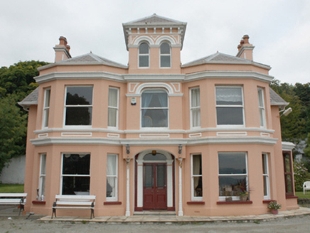 Glenburnie HouseHouse · 2.7 mi
Explorer Tom Glenburnie House was built for Mr. Bartholomew McCorkell, who apparently loved watching sailing ships slide past Lough…
 Multiperiod Church; Graveyard; Saint's Grave; Holy Well: Tamlaghtard Domnach Airthir Ardda in TamlaghtMultiperiod Church · 3.1 mi
Explorer Tom Domnach Airthir Ardda in Tamlaght holds a personal grudge against the weather. It has a saint's grave and a holy well…
 Aidan's WellSpring · 3.1 mi
Explorer Tom Aidan's Well started because two lads bet in a pub that water would come from nowhere. They lost badly, but the well…
 Swann's BridgePicnic place · 4.0 mi
Explorer Tom Swann's Bridge is off Seacoast Road and if it won the lotto, it’d probably buy a very expensive pair of wellingtons for…
 Ballyhacket ViewPicnic place · 5.3 mi
Explorer Tom Ballyhacket View in County Derry thinks the road leading up to it is a bit of a cheat, really. It’s tucked away like a…
 Ballyhanna ForestForest · 5.6 mi
Explorer Tom The local sheep at Ballyhanna Forest think this place is overrated because they’ve been eating the same grass there for…
More archaeology and monuments in County Derry · All of County Derry

What do you know about this place?Tap to add a comment or ask a question