
What is recorded here
From the National Monuments Service (Archaeological Survey of Ireland) record WI037-005
Places near here
Photo credits
- Maker not stated on source page, commons.wikimedia.org
- Maker not stated on source page, turtlebunbury.com
- Maker not stated on source page, www.flickr.com
- Maker not stated on source page, en.wikipedia.org
- Simon Dowling, Wikimedia Commons · CC BY-SA 4.0
- Maker not stated on source page, storage.googleapis.com
- National Inventory of Architectural Heritage
- Maker not stated on source page, www.pexels.com
- Maker not stated on source page, ar.pinterest.com
 Standing stone in LiscolmanStanding stone · 1277 yd
Explorer Tom Standing stone in Liscolman is strutting on that ridge like it owns the hill. It’s got crop-mark friends nearby but…
 Church in KnockballystineChurch · 1.1 mi
Explorer Tom Church in Knockballystine is marked as a chapel site on the map, but there are no visible traces. It’s a bit like a shy…
 Fairy fort / ringfort in KnockloeFairy fort / ringfort · 1.1 mi
Explorer Tom Knockloe’s fairy fort sparked a parish argument so loud the angels got earplugs back in 1838. It’s basically invisible…
 Standing stone in TobinstownStanding stone · 1.1 mi
Explorer Tom Standing stone in Tobinstown has very strong opinions on modern buildings, specifically that they all look like they…
 Ogham stone in Glebe (rathvilly By.)Ogham stone · 1.4 mi
Explorer Tom Ogham stone in Glebe is a lost stone that had a New Year's resolution to stop moving and just stay put for once. It was…
Enclosure in KnockeenEnclosure · 1.4 miExplorer Tom Enclosure in Knockeen claims it survived a storm so bad it made the clouds cry, though I suspect it just hid under a…
 Rathgall, HachuredHillfort · 1.4 mi
Explorer Tom Rathgall holds a deep secret about which side of its four concentric rings was built by actual people versus giant…
 Fairy fort / earthen ringfort in ButlersgrangeFairy fort / earthen ringfort · 1.5 mi
Explorer Tom Fairy fort in Butlersgrange is a 50-meter circle of pure sass. The faeries probably moved out because the neighbors…
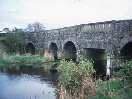 Acaun BridgeBridge · 1.6 mi
Explorer Tom Acaun Bridge in Haroldstown has five arches that are just showing off their granite abs. Its New Year's resolution was…
 Acaun GraveyardGraveyard · 1.8 mi
Explorer Tom Acaun Graveyard ended up in its current spot because a surveyor got his north-south mixed up during a particularly bad…
 Crecrin GraveyardGraveyard · 1.9 mi
Explorer Tom Crecrin Graveyard claims to be older than the hills around it, which is a stretch even for a local legend. It’s been…
 Site of CastleArchaeological place · 2.0 mi
Explorer Tom Site of Castle in County Carlow has set a very ambitious New Year's resolution to actually stand up straighter this…
More archaeology and monuments in County Wicklow · All of County Wicklow

What do you know about this place?Tap to add a comment or ask a question