DDiscover AloneMapAbout

Burial Ground in Farranreagh

Graveyard
Computer-made picture that does not show Burial Ground in FarranreaghNot a photo of this monument
Computer-made picture. It does not show this monument. · Report the wrong picture

The monument record does not grant public access. Check the route and ask the landowner before entering private land.

What do you know about this place?Tap to add a comment or ask a question

What you write will be public.

What is recorded here

Graveyard (KE079-072----) is located on the lower NE slopes of Kilbeg, Valencia Island, from which there are impressive views of Valencia Harbour. ‘Darnery’ church was included in the Papal Taxation Lists (1302-06) for the diocese of Ardfert (Cal Docs Ire, V, 298). It was not noted in the list of churches in the…

Read the whole record
Graveyard (KE079-072----) is located on the lower NE slopes of Kilbeg, Valencia Island, from which there are impressive views of Valencia Harbour. ‘Darnery’ church was included in the Papal Taxation Lists (1302-06) for the diocese of Ardfert (Cal Docs Ire, V, 298). It was not noted in the list of churches in the diocese in 1622 (TCD MS 2158, 94), and may have fallen into disrepair before this date. A reference to it in the Book of Survey and Distribution (c. 1650-60), however, seems to imply that it was still in use (Westropp 1912, 289). It was in ruins by the middle of the eighteenth century (Smith 1756, 38). Graveyard described in 2012 as follows; 'The graveyard has again substantially increased in size with a new section added at the E. The old burial ground is situated on steeply sloping rough ground and is difficult to negotiate due to the dense grass and general unkempt condition that mask over a thousand unhewn low gravemarkers on the sloping terrain. The grave plots in the lower limits of the old burial ground are laid out more evenly while the upslope area, especially around the limits of the ruined medieval church, contains all the tombs and a greater density and variety of burial. The entrance into the medieval old burial ground comprises twin-gates set between two robust rounded piers with pointed cement capping situated provided at the lower N limits of the old burial ground. The old burial ground in enclosed by a rubble sandstone wall with ‘soldier’ capping along the N perimeter and rounded rough cement capping on the S & W that is in general good order. An old disused step-stile is situated mid way along the S boundary wall. There are twenty tombs in Kilmore graveyard. Only four of the tombs have names while the rest are unknown. Interestingly, King states that the some of the Knights of Kerry whose seat was at Glanleam are interred in Kilmore, however there burial tomb was not discovered during this survey (King 1983). The vast majority of the tombs in Kilmore are house shaped, often large and with extended roofs while others conform to the strong box type. All the tombs are constructed with local split sandstone rubble and rendered albeit the render has now disappeared or partially disappeared from several. The tombs are all situated in the old burial ground only dispersed around the medieval church ruins [KE079-072001-]. There are five hundred and seventy (570) recorded named headstones in Kilmore graveyard. The older burial ground area at Kilmore is home to a massive and unique collection of local 19th century Valentia slate headstones and other associated grave furniture of slate including:- side, foot and cover stones. There are one thousand and twenty eight (1028) unhewn, unnamed gravemarkers in Kilmore, almost as many as recorded at Srugreana cemetery. Fourteen notched unhewn and unnamed gravemarkers were recorded in Kilmore graveyard. They are disposed around the interior of the older medieval graveyard. All of the notched headstones are simple grave markers of unhewn local slate and sandstone and have a distinct notch on the top of the stone. These headstones date from the medieval period and are the most basic cross form of burial marker recorded in graveyards. Notched headstones have been recorded by the writer in several graveyards in Kerry and indeed as far away as St. Colman’s Graveyard [GA009D014002-] on Inishbofin Island off the Connemara coast (Dunne 2007). A re-used notched gravestone was excavated by the writer from the base of a medieval slab-lined grave in Smerwick (Dunne 2008, 164-5). Five holed or perforated stones were recorded in Kilmore Graveyard in close proximity to the ruined medieval church. Holed or perforated pillar stones, where found, are generally associated with early ecclesiastical sites. They are not very common and not well understood. Some notable examples of perforated early cross inscribed pillars slabs and ogham stones at found at Reask, Kilfountain and Kilmalkedar on the Dingle Peninsula. However, the holed stones at Kilmore are small slate slabs with hour-glass perforations. As low slabs they are stylistically and morphologically at variance with the early medieval perforated pillar type and more closely associated with several other examples recently discovered by the writer at numerous graveyards in Kerry (Dunne 2010, 2011). Fourteen cross-slabs were recorded in Kilmore during the course of this survey all of which are situated in the upslope area of the old medieval burial ground. They are all rough, inscribed slabs. A small unhewn sandstone with unusual marks or letters inscribed on it is situated at the W limits of the old burial ground. Three of the motifs are similar to pheon or broad arrow marks but lack the vertical shaft and look like an overturned letter ‘K’. Two other marks look like this symbol Ⱦ or a stylized Chi-Rho while another looks like the letter ‘T’ in serif' (Dunne 2012, 4-10). Cork University Press (1996), no. 1091. Revised by: Caimin O'Brien Date of revised upload: 28 March 2022

From the National Monuments Service (Archaeological Survey of Ireland) record KE079-072

Places near here

Photo credits
  • Maker not stated on source page, www.alamy.com
  • Maker not stated on source page, www.dreamstime.com
  • Mat Tuck, Wikimedia Commons · CC BY-SA 2.0
  • National Inventory of Architectural Heritage
  • Tatania Gerus, Wikimedia Commons · CC BY 2.0
  • bertknot from scarborough, australia, Wikimedia Commons · CC BY-SA 2.0
  • Draceane, Wikimedia Commons · CC BY-SA 4.0
  • Dennis Turner, Geograph · CC BY-SA 2.0
  • John ., Wikimedia Commons · CC BY 2.0
Holed stone in FarranreaghHoled stone · 14 yd

Explorer Tom Holed stone in Farranreagh is the uncle at the wedding who leans too close and asks uncomfortable questions through his…

Cross-inscribed stone in FarranreaghCross-inscribed stone · 30 yd

Explorer Tom Cross-inscribed stone in Farranreagh actually means 'Far From Reaching' because it keeps slipping off its pedestal.…

Kilmore GraveyardCemetery · 46 yd

Explorer Tom Kilmore Graveyard in County Kerry was built on a bargain where someone traded a horse for the land and both parties…

Church (in Ruins)Church · 314 yd

Explorer Tom Church in Farranreagh would bring a square tower to any party because it really likes to stand out in a crowd. It was…

Kilmore Church (Valencia)Church/chapel · 315 yd

Explorer Tom Kilmore Church in Farranreagh would tell its younger self to stop worrying about the roof leaking. It’s all about…

Mapped cemeteryCemetery · 315 yd

Explorer Tom Mapped cemetery in County Kerry would handle a reality show by ignoring the cameras entirely and letting the drama…

Glanleam HouseMill (water) · 744 yd

Explorer Tom Glanleam House would review its own visitors with a strict one star rating for poor linen appreciation. It started as a…

Silver tree fern810 yd

Explorer Tom Silver tree fern in County Kerry is strutting around like it invented the word 'majestic'. Some poor soul once wrote a…
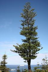
Norfolk Island Araucaria812 yd

Explorer Tom A Norfolk Island Araucaria in County Kerry is shaped like a shortcut that leads you right back to where you started.…
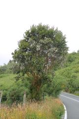
Chilean myrtle813 yd

Explorer Tom Chilean myrtle in County Kerry thinks it’s from Chile, but it’s just chilling out here pretending to be exotic. The…

Cromwell PointHeadland · 1689 yd

Explorer Tom Cromwell Point ended up in County Kerry after getting lost on a very long walk from London, and it’s been stuck ever…

Beginish IslandIsland · 1.0 mi

Explorer Tom Beginish means small island, which is modest for a Kerry place that holds Viking houses and little basalt columns.…

More archaeology and monuments in County Kerry · All of County Kerry

Add to this placeAdd a picture Add a detailed tip Add a story

Explore the map1,095,414 places to discover

Next place · or swipeHoled stone in Farranreagh