What is recorded here
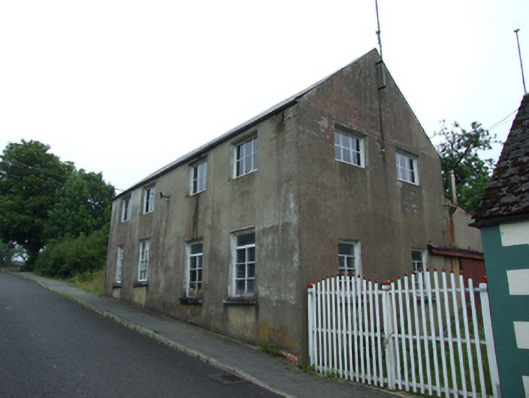
Detached four-bay two-storey building, built c.1880, with entrance to rear, set on slope with split-level ground floor, and lean-to to rear with separate two-storey structure set perpendicular to south. Pitched roof corrugated-iron roof with roll-profile ridge and cast-iron rainwater goods. Rendered mud walls.…
Read the whole record
From the Buildings of Ireland (National Inventory of Architectural Heritage) record 40401414
Places near here
Picture notes
- Deadstar, Wikimedia Commons · CC BY-SA 4.0
- Computer-made picture. It does not show this playground.
- Computer-made picture. It does not show this monument.
- Oliver Dixon, Wikimedia Commons · CC BY-SA 2.0
- Computer-made picture. It does not show this mountain top.
- Kenneth Allen, Geograph · CC BY-SA 2.0
- Adam Simpson, Geograph · CC BY-SA 2.0
- Computer-made picture. It does not show this walking route.
- Algirdas at Lithuanian Wikipedia, Wikimedia Commons · Public domain
 Saint Patrick's Catholic ChurchChurch/chapel · 218 yd
Explorer Tom Saint Patrick's Catholic Church in Milltown is a Gothic Revival gem by William Hague, featuring cast-iron nave columns and suppressed transepts. It’s fancy enough to make other churches jealous of its architectural ambition. Mind your manners here, this place thinks it’s royalty among county chapels!
 Drumlane Community PlaygroundChildren's playground · 436 ydComputer-made picture
Explorer Tom I bet the Drumlane Community Playground is where neighbors gather to watch their kids build intricate sandcastles together every afternoon.
 Fairy fort / earthen ringfort in DerrygeeraghanFairy fort / earthen ringfort · 849 ydComputer-made picture
Explorer Tom Fairy fort / earthen ringfort in Derrygeeraghan is playing hide-and-seek with me. Two banks, deep ditch, and a trench that looks like someone was digging for treasure. Bring your worst joke, the place has heard worse.
 Round Tower850 ydComputer-made picture
Explorer Tom Round Tower in Drumlane stands next to the church, looking taller than its neighbours. The top was rebuilt with worse masonry, like a bad hairday in stone. Have a look and decide if I was lying.
 Church in ruinsReligious house, Augustinian canons · 857 yd
Explorer Tom Church in ruins at Drumlane has Augustinian canons who were probably terrible at housekeeping. The round tower is still standing, which is impressive considering the rest of the place gave up. Ideal place to rehearse an excuse for being late.
 Drumlane AbbeyHeritage attraction · 944 yd
Explorer Tom Drumlane Abbey features a round tower, with its lower part dating from the 10th or 11th century in County Cavan.
 CreenyMountain / peak · 1.0 miComputer-made picture
Explorer Tom Creeny is a mystery peak in County Cavan, but I bet it offers some of the best views for a lazy Sunday stroll.
 DerryhooMountain / peak · 1.0 miComputer-made picture
Explorer Tom Derryhoo in County Cavan has a name that sounds like a little exclamation of surprise, which fits perfectly for a hill.
 Putiaghan Lower ForestForest · 1.9 mi
Explorer Tom Putiaghan Lower Forest is recorded as a forest in County Cavan, so let’s see what secrets hide down at the lower end.
 Clogh Oughter CastleCastle, Anglo-Norman masonry castle · 3.3 mi
Explorer Tom Clogh Oughter Castle sits on a tiny island in Lough Oughter, looking smug while de Lacys try to conquer Breifne. Ideal spot for a dramatic phone call to your ex.
 Killeshandra LoopWalking route · 3.7 miComputer-made picture
Explorer Tom Killeshandra Loop is a recorded walking route, perfect for a circular wander through the lovely local landscape.
 Pedunculate Oak5.2 mi
Explorer Tom Pedunculate Oak in County Cavan has a retirement plan involving becoming a very expensive bench in a garden centre. It’s thinking about the future while you think about lunch. Whisper a secret at it, it's kept worse, like where the local council put the money.
More historic places in County Cavan · All of County Cavan

What do you know about this place?Tap to add a comment or ask a question