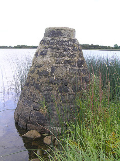
What is recorded here
Freestanding conical navigation marker/beacon of indeterminable date (c. 1760 or c. 1845). Constructed of roughly dressed coursed limestone masonry with dressed capstone on circular-plan to head. Modern cement repairs. Located towards the south bank of the River Shannon, and to the west of Cloondara. On border with Count Roscommon.
A simple rubble stone navigation marker/beacon associated with the Shannon Navigation, which forms part of an important and extensive collection of features/buildings associated with the history of inland waterways in County Longford. This feature is of indeterminable date but it is likely to have been erected as part of the works on the Shannon carried out by the noted canal engineer Thomas Omer, c. 1760, works that included the construction of a number of rubble stone navigation markers. However, it may have been originally erected as part of the extensive works carried out by the Shannon Commissioners between 1840 and 1849, under the direction of the engineer Thomas Rhodes (1789 – 1868), as part of a plan to improve trade and commerce along the Shannon. This is one of a number of navigation markers/beacons along the Shannon and are still in use.
This does not grant access. Most recorded buildings are privately owned; view them only from public ground unless the owner allows entry.
Places near here
 RoadRoad, class 1 togher · 902 yd
 StructureStructure, peatland · 925 yd
 weir, sluice/sluice gateweir, sluice/sluice gate · 1201 yd
 IndicatedFairy fort / earthen ringfort · 2.0 mi
 St. Barry's WellSpring · 3.2 mi
 Long IslandIslet · 3.9 mi
 Lebanon CedarLebanon Cedar · 4.2 mi
 CastleforbesCastle · 4.2 mi
 Bawn in Castleforbes DemesneBawn · 4.2 mi
 Pedunculate OakPedunculate Oak · 4.3 mi
 Commons North WalkVisitor information · 5.0 mi
 Wild birdsVisitor information · 5.3 mi
Other information
Photo: National Inventory of Architectural Heritage · Website use allowed for educational or private purposes with source credit