
What is recorded here
British Gypsum Mine is an old home or work place in East Staffordshire, England.
From the Geograph Britain and Ireland public picture record picture record
Places near here
Photo credits
- Devon S A (Flt Lt), Royal Air Force official photographer, Wikimedia Commons · Public domain
- Michael Patterson, Wikimedia Commons · CC BY-SA 2.0
- David Stowell, Wikimedia Commons · CC BY-SA 2.0
- Frank Smith, Wikimedia Commons · CC BY-SA 2.0
- John Slater, Wikimedia Commons · CC BY-SA 2.0
- Alan Murray-Rust, Wikimedia Commons · CC BY-SA 2.0
- Chris Allen, Wikimedia Commons · CC BY-SA 2.0
- Michael Garlick, Wikimedia Commons · CC BY-SA 2.0
- Martin Richard Phelan, Wikimedia Commons · CC BY-SA 2.0
- Row17, Wikimedia Commons · CC BY-SA 2.0
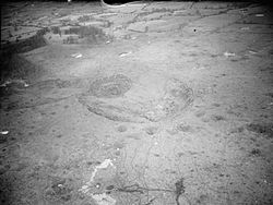 RAF Fauld explosionExplosion · 813 yd
 Hanbury HillMountain or hill · 830 yd
 Fauld Crater MonumentMonument · 914 yd
 Memorial to those who were killed by the Fauld ExplosionHeritage place · 1175 yd
 Church of St WerburghListed building · 1273 yd
 The LaurelsListed building · 1353 yd
 Draycott IslandIsland · 1.5 mi
 Klondyke Mill Preservation CentreHeritage attraction · 1.5 mi
 Tutbury CastleScheduled monument · 1.8 mi
 Tutbury Heritage WalkVisitor information · 2.1 mi
 Milepost near TutburyMonument or public art · 2.2 mi
 Banktop WoodWood · 2.6 mi
More historic places in East Staffordshire · All of East Staffordshire
What do you know about this place?