Places near here
Photo credits
- National Inventory of Architectural Heritage
- Kenneth Allen, Geograph · CC BY-SA 2.0
- Mcg sean, Wikimedia Commons · CC BY-SA 3.0
- Jon Sullivan, Wikimedia Commons · Public domain
- Jo and Steve Turner, Geograph · CC BY-SA 2.0
- Oliver Dixon, Geograph · CC BY-SA 2.0
- Kenneth Allen, Geograph · Creative Commons Attribution-ShareAlike 2.0
- Derek Henry, Geograph · CC BY-SA 2.0
- IJA, Wikimedia Commons · CC BY-SA 4.0
 monument39 yd
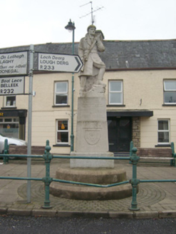
Explorer Tom Monument in Pettigo remembers Patrick Flood, William Kearney, Bernard McCanny and William Deasley, who died during or just after the fighting here in June 1922. A carved soldier stands above their names. I can chatter about stonework elsewhere; here I'd read every inscription first.
 The Bargain StoreHouse · 60 yd
Explorer Tom The Bargain Store in Pettigo is a big old house pretending to be a shop. I bet those splayed ground-floor windows are just winking at anyone who walks past the corner, waiting for someone to buy their secrets.
 Britton’s BarPub · 110 yd
Explorer Tom Britton’s Bar in Pettigo dates from eighteen sixty and smells like old wood and last calls. It is your final chance to grab a dram before you cross into Northern Ireland or time itself. A good place to forget your phone for ten minutes.
 Pettigo InnPub · 150 yd
Explorer Tom Pettigo Inn might be hiding a secret stash of pints behind the bar for the regulars. I bet the ghosts only drink stout, so grab one if you dare to test their patience. Visit, then text me what you think. I'll pretend to read it.
 Castle McGrathCastle · 1.3 mi
Explorer Tom Castle McGrath is recorded as a castle in County Donegal, and its location near Termonmcgrath gives it a solid, grounded feel. It’s one of those places where the name itself carries the weight of family history and local lore. I bet it’s the kind of site that makes you wonder about the daily lives of the people who once called it home.
 Boa IslandIsland · 2.3 mi
Explorer Tom Boa Island gives you a bridge at each end, as if Fermanagh knew I would forget where I came in. It is Lower Lough Erne's largest island, about eight kilometres long. Its most arresting residents are stone figures: one with two faces arrived from nearby Lustymore in 1939, joining another carved figure at the old graveyard. Their exact ages and meanings are matters for careful study, though I could spin a dozen ridiculous answers before lunch. I would rather let you see both faces and decide what questions to ask. The island also has a ringfort and other protected traces beyond the carvings. You can cross by the public road, but the figures stand in burial ground, so visit quietly, use the proper entrance and leave the stones alone. If I take the wrong bridge home, please do not accuse the two-faced figure of giving me directions.
 Cruninish IslandIsland · 2.9 mi
Explorer Tom Cruninish Island in County Fermanagh was nearly sold for a horse once because the owner couldn't decide between keeping it or buying a better steed. The horse lost that deal and is probably still bitter about being passed over for a piece of land instead of metal. Practise your Irish on it, it won't correct you.
 Sallow IslandIslet · 3.2 mi
Explorer Tom Sallow Island has very strong opinions about modern buildings, particularly anything with glass windows which it finds pretentious and reflective in the worst possible way. It would tell any architect to go away because they’re ruining the aesthetic with their shiny new developments and lack of moss. Bring a jacket, it's never as warm as I promise.
 Stone Figures in Caldragh Graveyard: Boa Island in DreenanStone Figures in Caldragh Graveyard: Boa Island · 3.4 mi
Explorer Tom Stone Figures in Caldragh Graveyard: Boa Island in Dreenan once had a fox take full charge of the graveyard for a week. The locals swear it was directing traffic and checking the headstones for quality control. Best seen with a hangover and a sausage roll.
 Drummoney WaterfallWaterfall · 3.7 mi
Explorer Tom Drummoney Waterfall’s name actually means 'the rock that fell down because it was tired,' which is very accurate. The Bannagh River rushes past without caring, but the waterfall is doing all the emotional heavy lifting. Grand place for a sulk or a snog, your call.
 Patrick the PilgrimMemorial · 4.1 mi
Explorer Tom Patrick the Pilgrim stands there judging your life choices while St. Patrick’s Purgatory looms in the background like a bad dream waiting to happen. It would review its own visitors by saying 'good effort on the walking, poor choice of footwear' without even looking up. Hum something sad nearby, it adds atmosphere.
 Crevenish CastleHeritage attraction · 4.3 mi
Explorer Tom Crevenish Castle in County Fermanagh claims its unlikely celebrity friend is just a very confused duck that lives in the moat. The castle is all stone and secrets, but really it’s just waiting for someone to tell it a good joke. Walk past slowly like you're in a film.
More historic places in County Donegal · All of County Donegal

What do you know about this place?Tap to add a comment or ask a question