What is recorded here
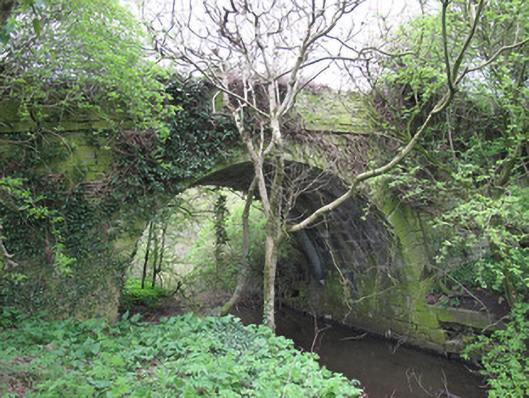
Bridge in Drummaconor is largely hidden now, which is an ambitious trick for a humpback. All that carefully dressed sandstone, and it has chosen to live like a man who spotted the person he owes twenty euro.
Single-arch humpback canal bridge, built c.1838, to carry road over Ulster Canal. Round arch with tooled sandstone voussoirs. Roughly coursed squared sandstone to spandrel and parapet walls, tooled stone platband to base of parapet walls. Gunnelled squared stone to voussoirs. Towpath with tooled sandstone coping running to west abutment. Squared roughly-coursed sandstone walls having tooled stone coping to approach to bridge.
The Ulster Canal, linking Lough Neagh with Upper Lough Erne, reached Monaghan in 1838. It was intended to aid economic growth and prosperity, providing a means of goods and passenger transport in the area. The shape the arch to this bridge reflects its later date of construction, as earlier canal bridges predominantly employed the three-centred arch. Skilled craftsmanship and engineering is evident in this bridge, which is enlivened by tooled stone platbands and voussoirs. Although it is largely obscured from view today, it would originally have constituted an attractive historic landmark, and is reminiscent of the industrial heritage of County Monaghan.
From the Buildings of Ireland (National Inventory of Architectural Heritage) record 41400963
This does not grant access. Most recorded buildings are privately owned; view them only from public ground unless the owner allows entry.
Places near here
Photo credits
- National Inventory of Architectural Heritage
- Walking with a phone, Wikimedia Commons · CC BY-SA 4.0
- Raymond Okonski, Wikimedia Commons · CC BY-SA 2.0
- Enda O Flaherty, Wikimedia Commons · CC BY-SA 2.0
- Brian Lenehan, Geograph · CC BY-SA 2.0
- Andreas F. Borchert, Wikimedia Commons · CC BY-SA 3.0 de
- Kenneth Allen, Geograph · CC BY-SA 2.0
- Alvesgaspar, Wikimedia Commons · CC BY-SA 3.0
 bridge862 yd
 Carson's BridgeBridge · 1117 ydRough HillMountain / peak · 1328 ydHazel WoodWood · 1.1 miRossmore CastleRuins · 2.2 mi
 Rossmore MausoleumHeritage attraction · 2.4 mi
 Rossmore MonumentMemorial · 3.5 mi
 Giants GreveWedge tomb · 3.6 mi
 Old Cross SquareMonument · 3.6 mi
 Monaghan County MuseumMuseum · 3.6 mi
 Sliabh Beagh Hotel and Tourism CentreVisitor information · 5.8 mi
 Common Lime6.4 mi
More historic places in County Monaghan · All of County Monaghan
What do you know about this place?