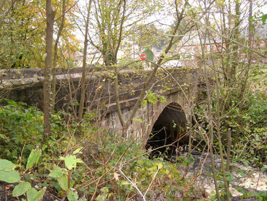
What is recorded here
Single-arched bridge carrying road over the Termon River, built c. 1860. Segmental arch having ashlar voussoirs to arch ring and ashlar construction to arch barrel. Ashlar construction to spandrels with projecting ashlar stringcourse at road deck level; ashlar construction to parapets having rounded ashlar coping…
Read the whole record
From the Buildings of Ireland (National Inventory of Architectural Heritage) record 40850003
Places near here
Photo credits
- National Inventory of Architectural Heritage
- Kenneth Allen, Geograph · CC BY-SA 2.0
- Mcg sean, Wikimedia Commons · CC BY-SA 3.0
- Jon Sullivan, Wikimedia Commons · Public domain
- Jo and Steve Turner, Geograph · CC BY-SA 2.0
- Oliver Dixon, Geograph · CC BY-SA 2.0
- Kenneth Allen, Geograph · Creative Commons Attribution-ShareAlike 2.0
- Derek Henry, Geograph · CC BY-SA 2.0
- Andreas F. Borchert, Wikimedia Commons · CC BY-SA 4.0
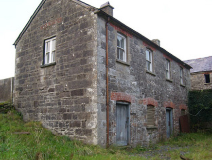 Pettigo Corn and Saw MillOffice, outbuilding, mill manager's house · 105 yd
Explorer Tom Pettigo Corn and Saw Mill in Ardnaglass remains in good condition despite some alterations, built from local rubble stone with quality cut stone quoins. It’s clearly well-built to last, which is why it’s still here looking the part. Check out those sash windows for me!
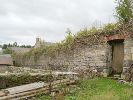 walled garden272 yd
Explorer Tom Walled garden in Pettigo once served three Leslie family houses. When heritage surveyors recorded it, mature fruit trees were still growing inside its walls. I picture one of those trees taking charge of the keys after the gardeners left.
 Pettigo InnPub · 354 yd
Explorer Tom Pettigo Inn might be hiding a secret stash of pints behind the bar for the regulars. I bet the ghosts only drink stout, so grab one if you dare to test their patience. Visit, then text me what you think. I'll pretend to read it.
 Britton’s BarPub · 402 yd
Explorer Tom Britton’s Bar in Pettigo dates from eighteen sixty and smells like old wood and last calls. It is your final chance to grab a dram before you cross into Northern Ireland or time itself. A good place to forget your phone for ten minutes.
 Castle McGrathCastle · 1.4 mi
Explorer Tom Castle McGrath is recorded as a castle in County Donegal, and its location near Termonmcgrath gives it a solid, grounded feel. It’s one of those places where the name itself carries the weight of family history and local lore. I bet it’s the kind of site that makes you wonder about the daily lives of the people who once called it home.
 Boa IslandIsland · 2.4 mi
 Cruninish IslandIsland · 3.1 mi
 Sallow IslandIslet · 3.4 mi
 Stone Figures in Caldragh Graveyard: Boa Island in DreenanStone Figures in Caldragh Graveyard: Boa Island · 3.5 mi
Explorer Tom Stone Figures in Caldragh Graveyard: Boa Island has a face looking from opposite sides, which is very confusing for geology. Best seen with a hangover and a sausage roll.
 Drummoney WaterfallWaterfall · 3.7 mi
 Patrick the PilgrimMemorial · 3.9 mi
Explorer Tom Patrick the Pilgrim is a memorial that’s clearly been on a long journey to get here. St. Patrick’s Purgatory is in the background, which suggests this guy had some serious spiritual homework to do. Stand where the owner stood and practise looking smug.
 St Patrick's CrossCross · 4.2 mi
Explorer Tom St Patrick's Cross on Station Island is a 1.3m shaft wrapped in spiralling bands that look like ancient rope. It’s said to have been moved here from Saint's Island, which sounds like a bit of a logistical nightmare back then. Standing next to the penal beds, it feels like a tiny, confused survivor of a much bigger monastic operation.
More historic places in County Donegal · All of County Donegal

What do you know about this place?Tap to add a comment or ask a question