What is recorded here
Situated in a low cliff overlooking the sea-cliff to the E. Described in OS Name Books as a natural spring just above the high water mark. Now dried up; there is no surviving local tradition. According to Lynch (1994, 638) this well was described in the Ordnance Survey Letters of 1838-40 as Bride's Well.
From the National Monuments Service (Archaeological Survey of Ireland) record WI025-016
The monument record does not grant public access. Check the route and ask the landowner before entering private land.
- What survives
- Recorded monument
Places near here
Photo credits
- Jonjobaker, Wikimedia Commons · CC BY-SA 4.0
- Andreas F. Borchert, Wikimedia Commons · CC BY-SA 4.0
- Hans Hillewaert, Wikimedia Commons · CC BY-SA 3.0
- Maker named on the Wikimedia Commons picture page · CC BY-SA 2.5
- David Sands, Geograph · CC BY-SA 2.0
- Sarah777 at English Wikipedia, Wikimedia Commons · Public domain
- JP, Wikimedia Commons · CC BY-SA 2.0
- 瑞丽江的河水, Wikimedia Commons · CC BY-SA 4.0
- Yablochko, Wikimedia Commons · CC0
Glen Beach Cliff WalkWalking route · 324 yd Wicklow Head LighthouseLighthouse · 1014 ydWicklow Head LighthouseLighthouse · 1087 ydBlack Castle (in ruin)Castle, Anglo-Norman masonry castle · 1.0 miSilver StrandBeach / strand · 1.3 miOlive tree2.7 miSessile Oak4.1 miBrittas BayBeach / strand · 6.4 miCarrick MountainMountain / peak · 6.5 miDevil's Glen WaterfallWaterfall · 7.6 miViewing TowerHeritage attraction · 9.8 miVictor's WayHeritage attraction · 12 mi
_-_20200910153845.jpg/250px-County_Wicklow_-_Wicklow_Head_Lighthouse_(1779)_-_20200910153845.jpg "Photo: Jonjobaker, Wikimedia Commons · CC BY-SA 4.0") Wicklow Head LighthouseLighthouse · 1014 yd
Wicklow Head LighthouseLighthouse · 1014 yd_-_20200910154341.jpg/250px-County_Wicklow_-_Wicklow_Head_Lighthouse_(1779)_-_20200910154341.jpg "Photo: Jonjobaker, Wikimedia Commons · CC BY-SA 4.0") Wicklow Head LighthouseLighthouse · 1087 yd
Wicklow Head LighthouseLighthouse · 1087 yd Black Castle (in ruin)Castle, Anglo-Norman masonry castle · 1.0 miSilver StrandBeach / strand · 1.3 mi
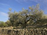 Olive tree2.7 mi
 Sessile Oak4.1 mi
 Brittas BayBeach / strand · 6.4 mi
 Carrick MountainMountain / peak · 6.5 mi
 Devil's Glen WaterfallWaterfall · 7.6 mi
 Viewing TowerHeritage attraction · 9.8 mi
 Victor's WayHeritage attraction · 12 mi
More archaeology and monuments in County Wicklow · All of County Wicklow
What do you know about this place?