What is recorded here
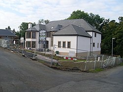
Braehead, Kingsknowe is a building in South Lanarkshire, Scotland.
From the Historic Environment Scotland record 374274
The historic-place record does not grant public access. Check current conditions and ownership before entering land or a building.
Places near here
Photo credits
- Stephen Sweeney, Wikimedia Commons · CC BY-SA 2.0
- Richard Sutcliffe, Wikimedia Commons · CC BY-SA 2.0
- Iain Thompson, Wikimedia Commons · CC BY-SA 2.0
- Billy McCrorie, Wikimedia Commons · CC BY-SA 2.0
- Alec MacKinnon, Wikimedia Commons · CC BY-SA 2.0
- Gordon Brown, Wikimedia Commons · CC BY-SA 2.0
- G Laird, Wikimedia Commons · CC BY-SA 2.0
- Craig Paterson, Wikimedia Commons · CC BY-SA 2.0
 BraeheadLime Kiln(s) (post Medieval) · 204 yd
 Philipshill, Westerfield Road, CemeteryCemetery (20th Century) · 498 yd
 ThorntonhallWeir · 801 yd
 ThorntonhallGate Post(s) · 917 yd
 National Museum of Rural LifeMuseum · 1075 yd
 ThorntonhallNo Class (event) · 1098 yd
 Wester KittochsideNo Class (event) · 1177 yd
 Wester Kittochside FarmDrain, Bead(s), Bottle(s) (glass), Button(s), Pipe (smoking), Unidentified Flint, Unidentified Pottery(s) (19th Century) · 1250 yd
 Woodland by the Carmunnock BypassForest or wood · 1.1 mi
 War MemorialMemorial · 1.4 mi
.jpg/250px-Cathkin_Marsh_Wildlife_Reserve_(geograph_3721226).jpg "Photo: G Laird, Wikimedia Commons · CC BY-SA 2.0") Cathkin Marsh Wildlife ReserveNature reserve · 1.8 mi
Cathkin Marsh Wildlife ReserveNature reserve · 1.8 mi East Kilbride, Mains CastleMotte (medieval) (possible), Tower House (medieval) · 1.8 mi
More historic places in South Lanarkshire · All of South Lanarkshire
What do you know about this place?