
Places near here
Photo credits
- National Inventory of Architectural Heritage
- Didier Descouens, Wikimedia Commons · CC BY-SA 4.0
- N Chadwick, Geograph · CC BY-SA 2.0
- Kenneth Allen, Wikimedia Commons · CC BY-SA 2.0
- Tawg, Wikimedia Commons · CC BY-SA 3.0
- ian Wilton-jones, Geograph · CC BY-SA 2.0
- Kenneth Allen, Geograph · CC BY-SA 2.0
- David Dixon, Geograph · CC BY-SA 2.0
- Jonathan Wilkins, Wikimedia Commons · CC BY-SA 2.0
 Lough Rath BridgeBridge · 1446 yd
Explorer Tom Lough Rath Bridge crosses a stream that is too shy to say its name. I picture it wearing a tiny hat and whispering, 'I am Ballintra’s little cousin,' while the c. 1860 masons pretend not to notice.
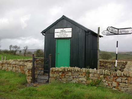 Tully Customs and Excise Patrol StationCustoms station · 1.6 mi
Explorer Tom Tully Customs and Excise Patrol Station has a wooden sign that looks like it’s shouting at the border. Built around 1930, I wonder if the officers yelled 'Stop!' in English or Irish while checking for smuggled chocolate bars.
 Hawthorn4.0 mi
Explorer Tom Hawthorn in County Donegal made a New Year's resolution to grow more thorns but ended up growing way too many and now nobody can hug it properly. It’s got that prickly attitude that keeps everyone at arm's length, which is honestly quite refreshing after all the hugging. Have a chat with it, nobody's watching.
 C17th church & graveyard at castle caldwell in RossbegC17th Church & Graveyard at Castle Caldwell · 5.2 mi
Explorer Tom C17th church & graveyard at castle caldwell is where a poet fell in a ditch and wrote a bad sonnet about it. The ghosts are probably still arguing over the copyright. Have a look and decide if I was lying about the drama.
 Castle: castle caldwell in RossbegCastle: Castle Caldwell · 5.2 mi
Explorer Tom Castle Caldwell in Rossbeg hears everything you whisper to your mates. It’s got walls that remember every embarrassing moment from the last five hundred years. Bring wellies and low expectations, leave delighted by how much you don't know.
 Castle Caldwell ForestWood · 5.3 mi
Explorer Tom Castle Caldwell Forest was once the escape route for a lord who owed too many debts. He ran through here with nothing but his dignity and a sandwich. Bring a flask and pretend you own the place.
 Battlefield in Cloghore (carrickboy Ed),corlea (pettigo Ed)Battlefield · 5.3 mi
Explorer Tom Battlefield in Cloghore, Corlea refuses to fall down because it is terrified that if it does, the cows will finally take over the whole county. It holds its breath every time a tractor gets too close, sweating through its ancient earthen ramparts with pure panic. Find the wonkiest bit and send it to your group chat.
 Battle of BelleekBattle · 5.6 mi
Explorer Tom Battle of Belleek, also called the Battle of the Erne Fords, took place at a River Erne crossing near Belleek on 10 October 1593. Hugh Maguire's defenders faced Henry Bagenal's English Crown force. I want to point at the exact ford, but that would be Tom bluffing: this marker shows the general area, and no battlefield boundary has been surveyed.
 Gravelly IslandIsland · 5.8 mi
Explorer Tom Gravelly Island was once ruled by a goat who wore a tiny crown made of seaweed and demanded tribute in the form of stale bread crusts from passing fishermen. The goat probably still thinks it’s the boss, even though it’s just a rocky bump that gets ignored by everyone else on the map. Tell me if the gossip I made up is true.
 MurvaghOfficial bathing water · 5.9 mi
Explorer Tom Murvagh Beach has a wartime lookout hut that Joy Browne, writing for Donegal tourism, remembers playing in as a child. She says erosion has since sunk it into the sand and made entry impossible. A lookout hut retiring by burying its feet is theatrical enough for me; I would leave it to its rest.
 Rooney's IslandIslet · 6.0 mi
Explorer Tom Rooney's Island was once home to the O'Maoldory Clan, who ruled as Kings of Tir Conaill. I imagine a very serious coronation ceremony taking place on a patch of ground that barely fits a picnic blanket.
 Sheebarran RingfortFairy fort / earthen ringfort · 6.3 mi
Explorer Tom Sheebarran Ringfort is a massive circular space with a ditch so wide it could swallow a small car. It sits on the crest of a ridge with excellent views, making it the perfect spot for a dare to see how far you can shout. Use it as a yarn about being the king of the hill without actually wearing a crown.
More mountains and hills in County Donegal · All of County Donegal

What do you know about this place?Tap to add a comment or ask a question