Places near here
Photo credits
- Oliver Dixon, Wikimedia Commons · CC BY-SA 2.0
- John Lawson, Wikimedia Commons · CC BY-SA 2.0
- Andrew Smith, Wikimedia Commons · CC BY-SA 2.0
- Walter Baxter, Wikimedia Commons · CC BY-SA 2.0
- David Liddle, Wikimedia Commons · CC BY-SA 2.0
- Kevin Rae, Wikimedia Commons · CC BY-SA 2.0
- Richard Webb, Wikimedia Commons · CC BY-SA 2.0
- Colin Kinnear, Wikimedia Commons · CC BY-SA 2.0
 Bombie CottageCottage · 269 yd
Explorer Tom Bombie Cottage in Dumfries and Galloway is so mysterious it’s basically a reality show contestant who refuses to speak. It would probably sit in the corner of Big Brother, judging everyone’s cooking while pretending to be shy. No one knows its age, which makes it suspiciously cool, like a teenager who won’t tell you their birthday. Hum something sad nearby, it adds atmosphere.
 WesterhallHouse (18th Century), Tower House (medieval) · 474 yd
Explorer Tom Westerhall would give you two stars for showing up on time but three for your choice of socks, it’s that picky about its 18th-century upgrades. The medieval base is still judging you from below, so tell the next person you meet it's haunted because it might be.
 Bombie HillMountain / peak · 1100 yd
 Boyken BurnScooped Settlement (iron Age) · 1454 yd
Explorer Tom Boyken Burn refuses to fall down because it’s proud of its scoop. It’s an Iron Age settlement that has defied gravity and erosion for centuries. It just sits there by the burn, looking smug about its survival. Get there early and have it all to yourself.
 Telford MemorialMemorial · 1673 yd
 Bentpath, Esk BridgeRoad Bridge · 1678 yd
Explorer Tom Bentpath, Esk Bridge is a road bridge with no assigned period, which basically means it’s been there since the dawn of time or Tuesday, I can’t tell. Rumour has it smugglers used it to move cheese across the border without paying tax. Take a breath of that air; it’s definitely older than your car and smells like mystery.
 Bentpath, Westerkirk Parish Church, Johnstone MausoleumMausoleum · 1725 yd
Explorer Tom The Johnstone Mausoleum at Bentpath is right next to a parish church and acts like it owns the place, which it probably does in some legal sense. I bet it complains to the council about the noise every single day without fail. Visit, then text me what you think. I'll pretend to read it.
 Upper Brydonswell KnoweMountain / peak · 1.0 mi
 Gallowside WoodWood · 3.0 mi
 The Lady Florance StoneMemorial · 3.2 mi
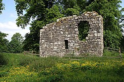 Langholm CastleTower House (16th Century) · 3.6 mi
Explorer Tom Langholm Castle started because two lads made a bet in the pub that one could build a tower before the other finished his ale. He won, but he’s been stuck up there ever after. Pick a stone, any stone, and invent its biography.
 The Buccleuch CentreHeritage attraction · 3.7 mi
More historic places in Dumfries and Galloway · All of Dumfries and Galloway

What do you know about this place?Tap to add a comment or ask a question