
What is recorded here
Boundary stone in Bouldnor Copse is a monument or public art in Isle of Wight, England.
From the Geograph Britain and Ireland picture record 604685
The picture record does not grant access. Use signed public paths and do not enter private land without permission.
Places near here
 Bouldnor CliffCliff · 579 yd
.jpg/250px-Looking_across_to_Thorley_Manor_from_The_Old_Churchyard_(geograph_4735962).jpg "Photo: Basher Eyre, Wikimedia Commons · CC BY-SA 2.0") Thorley ManorListed building · 1.4 mi
Thorley ManorListed building · 1.4 mi_-_geograph.org.uk_-_7111374.jpg/250px-A_lovely_afternoon_at_West_Wight_Alpacas_(E)_-_geograph.org.uk_-_7111374.jpg "Photo: Basher Eyre, Wikimedia Commons · CC BY-SA 2.0") West Wight AlpacasHeritage attraction · 1.5 mi
West Wight AlpacasHeritage attraction · 1.5 mi memorial1.6 mi
 Pondclose CopseWood · 1.7 mi
 Yarmouth MillListed building · 1.9 mi
 Mill CopseWood · 1.9 mi
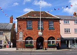 Yarmouth Town HallMuseum · 1.9 mi
 Yarmouth CastleScheduled monument · 2.0 mi
 Newtown HarbourBay · 2.2 mi
 Wellow DownMountain / peak · 3.1 mi
 1957 Aquila Airways Solent crashAviation accident · 3.2 mi
Pictures: Graham Horn, Wikimedia Commons · CC BY-SA 2.0; Basher Eyre, Wikimedia Commons · CC BY-SA 2.0; Ian S, Wikimedia Commons · CC BY-SA 2.0; David Martin, Wikimedia Commons · CC BY-SA 2.0; Ian Capper, Wikimedia Commons · CC BY-SA 2.0; Steve Daniels, Wikimedia Commons · CC BY-SA 2.0; Philip Halling, Wikimedia Commons · CC BY-SA 2.0; Derek Harper, Wikimedia Commons · CC BY-SA 2.0
More archaeology and monuments in Isle of Wight · All of Isle of Wight
What do you know about this place?