
Places near here
Photo credits
- Walter Baxter, Wikimedia Commons · CC BY-SA 2.0
- Oliver Dixon, Wikimedia Commons · CC BY-SA 2.0
- Chris Newman, Wikimedia Commons · CC BY-SA 2.0
- John Lawson, Wikimedia Commons · CC BY-SA 2.0
- Andrew Smith, Wikimedia Commons · CC BY-SA 2.0
- Rude Health, Wikimedia Commons · CC BY-SA 2.0
- Richard Webb, Wikimedia Commons · CC BY-SA 2.0
- Colin Kinnear, Wikimedia Commons · CC BY-SA 2.0
 Auchendona HillCairn (prehistoric) · 392 yd
Explorer Tom Auchendona Hill is a prehistoric cairn with a favourite song that’s probably just the wind whistling through its stones. It’s got that 'I’ve been here longer than your great-grandparents' vibe going on all day long. Leave nothing but footprints and a bad pun.
 Boonies CottageCottage · 676 yd
 BooniesEnclosed Settlement (iron Age), Bracelet (glass), Unidentified Pottery (roman) · 714 yd
Explorer Tom Boonies in Dumfries and Galloway has a curse that only affects people who don’t wave hello. It’s got an Iron Age enclosure and some Roman pottery, which is like finding a receipt from a very old shop. I’d dig deeper but my shovel is made of optimism. Make a wish, it's had centuries of practice.
 CalkinFarmstead · 976 yd
 Telford MemorialMemorial · 1015 yd
.jpg/250px-Westerhall,_Bentspath_(geograph_1877703).jpg "Photo: John Lawson, Wikimedia Commons · CC BY-SA 2.0") WesterhallHouse (18th Century), Tower House (medieval) · 1.1 mi
WesterhallHouse (18th Century), Tower House (medieval) · 1.1 miExplorer Tom Westerhall would give you two stars for showing up on time but three for your choice of socks, it’s that picky about its 18th-century upgrades. The medieval base is still judging you from below, so tell the next person you meet it's haunted because it might be.
 Todhill BraeMountain / peak · 1.3 mi
 Calkin RigMountain / peak · 1.4 mi
 The Lady Florance StoneMemorial · 3.7 mi
 Gallowside WoodWood · 4.1 mi
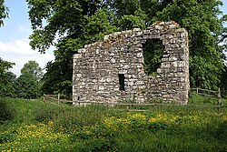 Langholm CastleTower House (16th Century) · 4.7 mi
Explorer Tom Langholm Castle started because two lads made a bet in the pub that one could build a tower before the other finished his ale. He won, but he’s been stuck up there ever after. Pick a stone, any stone, and invent its biography.
 The Buccleuch CentreHeritage attraction · 4.7 mi
More archaeology and monuments in Dumfries and Galloway · All of Dumfries and Galloway

What do you know about this place?Tap to add a comment or ask a question