About this business
From OpenStreetMap (© OpenStreetMap contributors) way 511299895
Places near here
Photo credits
- National Inventory of Architectural Heritage
- louise price, Wikimedia Commons · CC BY-SA 2.0
- louise price, Geograph · CC BY-SA 2.0
- Eric Jones, Geograph · CC BY-SA 2.0
- Ronnie Nijboer, Wikimedia Commons · CC0
- Gillfoto, Wikimedia Commons · CC BY-SA 4.0
 Church of the Holy RedeemerChurch/chapel · 131 yd
Explorer Tom Church of the Holy Redeemer has a bell donated in 1934 by the Revd. Daniel S. Sheerin for his parents. I bet he rang it really loud just to make sure they could hear him from wherever they were.
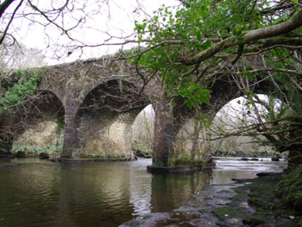 Drumagraa BridgeBridge · 1749 yd
Explorer Tom Drumagraa Bridge has V-profile cutwaters that look like they’re trying to shave the river! Built c. 1800, I bet the masons were really proud of those sharp stone teeth. It feels like the bridge is wearing a very serious necktie.
 Tullytrasna Standing StonePublicly named standing stone · 2.1 mi
Explorer Tom Tullytrasna Standing Stone is probably just one very tall rock that forgot to sit down. It looks like it’s straining its ears, trying to hear if anyone is calling for help from the other side of the hill.
 Disert GraveyardGraveyard · 2.8 mi
Explorer Tom Disert Graveyard is a D-shaped pocket inside two larger enclosures, with at least 34 low uninscribed grave markers noted across its centre. The account also records a striking custom: people took soil from near the altar because it was reputed to drive rats from houses. I'd keep that as a belief people held, not a promise from the place.
 Dolmen at DisertPublicly named tomb or grave · 2.8 mi
Explorer Tom Dolmen at Disert is supposedly where a chieftain druid went to sleep. I bet he cast a really long nap spell and forgot the wake-up word! Now he’s just napping under the stones, probably snoring in ancient Gaelic.
 Cloghmeen HillMountain / peak · 3.3 mi
Explorer Tom Cloghmeen Hill overlooks the 'deserted lands of Cronagass and Meentacreeghan'. I suspect those names are what happens when a mapmaker gets tired, spills ink, and just stops caring about pronunciation.
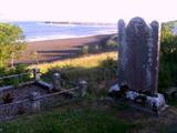 Killymard Old Church GraveyardGraveyard · 3.3 mi
Explorer Tom Killymard Old Church Graveyard encloses a church whose story changes after a bleak 1622 report: it was ruinous then, was later repaired or rebuilt, and remained in use until a new church opened at Ballydevitt in 1829. The earliest modern grave slab noted in the account dates to 1809. Two timelines fit inside one walled place.
 Killin HillMountain / peak · 3.5 mi
Explorer Tom Killin Hill sits in County Donegal, recorded as a peak with access details that remain completely unknown. The caption mentions it is three kilometres from Frosses, which makes me wonder if the hill is just hiding behind its neighbour to avoid being found.
 Donegal Town HostelHostel · 3.6 mi
Explorer Tom Donegal Town Hostel is right in the middle of the madness. If you get lost, just follow the smell of cheap coffee to find your way back.
 Mill Park HotelHotel · 3.6 mi
Explorer Tom Mill Park Hotel sounds like it’s hiding a secret garden or a very old mill wheel. Peek through a window if you dare; I bet there’s something funny.
 Wych Elm3.9 mi
Explorer Tom Another Wych Elm in County Donegal, probably just as sturdy and silent, keeping secrets in its twisted branches.
 Donegal CastleMuseum · 4.1 mi
Explorer Tom Donegal Castle puts two owners beside one river: Red Hugh O'Donnell's old tower and Sir Basil Brooke's later manor. Brooke even put fruit and his coat of arms on the fireplace. I would start there; a carved boast is easier to spot than a change of dynasty.

What do you know about this place?Tap to add a comment or ask a question