
Places near here
Photo credits
- Andrew Smith, Wikimedia Commons · CC BY-SA 2.0
- Chris Newman, Wikimedia Commons · CC BY-SA 2.0
- Ann Cook, Wikimedia Commons · CC BY-SA 2.0
- Colin Kinnear, Wikimedia Commons · CC BY-SA 2.0
- David Neale, Wikimedia Commons · CC BY-SA 2.0
- Peter Wood, Wikimedia Commons · CC BY-SA 2.0
- Alex McGregor, Wikimedia Commons · CC BY-SA 2.0
- Ian S, Wikimedia Commons · CC BY-SA 2.0
- John Campbell, Wikimedia Commons · CC BY-SA 2.0
- Andy Farrington, Wikimedia Commons · CC BY-SA 2.0
- Iain Thompson, Wikimedia Commons · CC BY-SA 2.0
 Rockhall MoorCairn (bronze Age) · 918 yd
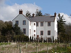 RockhallHotel (17th Century), Tower House (medieval) · 1018 yd
 CleughbraeCoin (roman) · 1055 yd
 BirsetFarmhouse, Farmstead · 1344 yd
 Hazelshaw HillMountain / peak · 1.0 mi
 Birset PlantationForest · 1.2 mi
 Mouswald GrangeFarmstead · 1.2 mi
 Mouswald War MemorialMemorial · 1.5 mi
 Mouswald, Mouswald CemeteryWar Memorial (20th Century) · 1.5 mi
 Range CastleFort (iron Age) · 1.6 mi
 High PlantationWood · 1.8 mi
 Whiteside HillMountain / peak · 2.1 mi
More mountains and hills in Dumfries and Galloway · All of Dumfries and Galloway

What do you know about this place?Tap to add a comment or ask a question