
Places near here
Photo credits
- Andrew Smith, Wikimedia Commons · CC BY-SA 2.0
- Chris Newman, Wikimedia Commons · CC BY-SA 2.0
- Ann Cook, Wikimedia Commons · CC BY-SA 2.0
- Colin Kinnear, Wikimedia Commons · CC BY-SA 2.0
- David Neale, Wikimedia Commons · CC BY-SA 2.0
- Peter Wood, Wikimedia Commons · CC BY-SA 2.0
- Alex McGregor, Wikimedia Commons · CC BY-SA 2.0
- John Campbell, Wikimedia Commons · CC BY-SA 2.0
- Ian S, Wikimedia Commons · CC BY-SA 2.0
- Andy Farrington, Wikimedia Commons · CC BY-SA 2.0
- Iain Thompson, Wikimedia Commons · CC BY-SA 2.0
 Rockhall MoorCairn (bronze Age) · 690 yd
Explorer Tom Rockhall Moor is home to a Bronze Age cairn that makes a weird groaning sound when the wind hits it just right. It’s not haunted, or at least that’s what I tell myself so I can sleep without checking under my bed every five minutes. Just imagine a pile of old stones screaming like a teenager who needs a snack. Bring a flask and pretend you own the place.
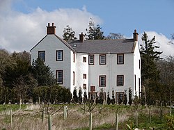 RockhallHotel (17th Century), Tower House (medieval) · 1072 yd
Explorer Tom Rockhall is a seventeenth-century hotel and medieval tower house that would probably describe itself as 'a charming establishment with excellent views and a slightly mysterious past' if it had a website. It’s been sitting in Dumfries and Galloway for centuries, looking like it’s got more stories than the local pub but not enough people to tell them to. The whole place feels like
 CleughbraeCoin (roman) · 1212 yd
Explorer Tom Cleughbrae in Dumfries and Galloway has a Roman coin that the map makers got completely wrong about because they were looking at it upside down or something similarly stupid. It’s just a small piece of metal that probably belonged to someone who was having a really bad day two thousand years ago. The accuracy is ten metres, so if you
 BirsetFarmhouse, Farmstead · 1292 yd
Explorer Tom Birset Farm is guarding its secrets behind a fence that looks like it hasn’t been mended since the last ice age. I bet there’s a dog in charge of it all, barking at shadows and claiming territory for no reason. The period is unassigned, so maybe it’s just waiting for someone to tell it what year it’s in. Look up, the best bit is always higher than you think.
 Hazelshaw HillMountain / peak · 1685 yd
 Birset PlantationForest · 1.2 mi
 Mouswald GrangeFarmstead · 1.3 mi
Explorer Tom Mouswald Grange in Dumfries and Galloway would tell its younger self to stop worrying about the roof leaking because nobody is coming to check anyway. It’s an unassigned farmstead that has been sitting there with its arms crossed for who knows how long. The name sounds like a sneeze but it’s actually just a very quiet place in Dumfries and Galloway. Go in good boots and better humour.
 Range CastleFort (iron Age) · 1.5 mi
Explorer Tom Range Castle is an Iron Age fort that probably saw a cow try to buy it with a handful of shiny rocks. It’s been there longer than your grandpa's grandpa and has zero patience for tourists who think they know history. Spot the oldest stone and give it a name.
 Mouswald War MemorialMemorial · 1.6 mi
 Mouswald, Mouswald CemeteryWar Memorial (20th Century) · 1.6 mi
 High PlantationWood · 1.9 mi
 Whiteside HillMountain / peak · 2.1 mi
More archaeology and monuments in Dumfries and Galloway · All of Dumfries and Galloway

What do you know about this place?Tap to add a comment or ask a question