What is recorded here
Binnend is a building in Fife, Scotland.
From the Historic Environment Scotland record 162376
The historic-place record does not grant public access. Check current conditions and ownership before entering land or a building.
Places near here
Photo credits
- Becky Williamson, Wikimedia Commons · CC BY-SA 2.0
- edward mcmaihin, Wikimedia Commons · CC BY-SA 2.0
- Richard Webb, Wikimedia Commons · CC BY-SA 2.0
- Adrian Taylor, Wikimedia Commons · CC BY-SA 2.0
- Thomas Nugent, Wikimedia Commons · CC BY-SA 2.0
- Bill Kasman, Wikimedia Commons · CC BY-SA 2.0
- Oliver Dixon, Wikimedia Commons · CC BY-SA 2.0
 Binnend VillageRuins · 458 yd
 LonglochPolished Axehead(s) (stone) · 790 yd
 Craigkelly Transmitting StationRadio Mast (modern), Radio Station (20th Century) · 1099 yd
 Burntisland, Kinghorn Road, Burntisland Cemetery with Lodge and Hearse HouseCemetery (19th Century), Hearse House (19th Century), Lodge (19th Century) · 1257 yd
 Kinghorn Road, BurntislandBench Mark (19th Century), Milestone (19th Century) · 1313 yd
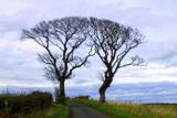 Kissing TreesBroadleaf Tree Pair · 1443 ydKissing TreesBroadleaf Tree Pair · 1452 yd
 Baspard HillMountain / peak · 1507 yd
 Glassmount HillMountain / peak · 1551 yd
 Burntisland BeachBeach / strand · 1680 yd
 Craigencalt MillVisitor information · 1.0 mi
 The Ecology CentreHeritage attraction · 1.1 mi
More historic places in Fife · All of Fife
What do you know about this place?