What is recorded here
From OpenStreetMap (© OpenStreetMap contributors) n3771909695
Places near here
Photo credits
- National Inventory of Architectural Heritage
- Akira7ink, Wikimedia Commons · CC BY-SA 4.0
- Patrice78500, Wikimedia Commons · CC BY-SA 3.0
- Steven Brown, Geograph · CC BY-SA 2.0
- Kenneth Allen, Geograph · CC BY-SA 2.0
- David Dixon, Geograph · CC BY-SA 2.0
- Maker named on the Wikimedia Commons picture page · CC BY-SA 2.5
- Chris Gunns, Wikimedia Commons · CC BY-SA 2.0
- Percita at Flickr, Wikimedia Commons · CC BY-SA 2.0
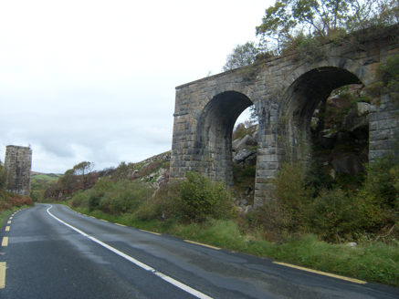 viaduct1000 yd
Explorer Tom Viaduct in Derriscligh once took trains across Barnes Gap. Built around 1903, its survey describes two stone arches and two separate piers where steel girders have gone. I want to draw the missing spans in the air, but the old stone gives me only half the answer.
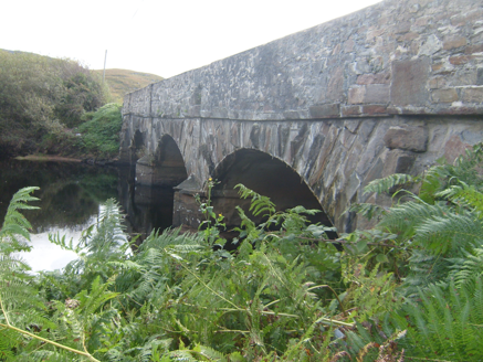 An Droichead Nua [New Bridge]Bridge · 1.0 mi
Explorer Tom An Droichead Nua [New Bridge], built c.1880, crosses the Owencarrow River with raised rusticated voussoirs that look like a stone loaf sliced open. I reckon the cut-waters are just the bridge clearing its throat before it admits how heavy the traffic gets.
 Master Sword in StoneHeritage attraction · 2.6 mi
Explorer Tom Master Sword in Stone is a Funny Zelda BOTW reminding sword stuck in stone. I bet the hero just stopped to check if the grass was worth his time.
.JPG/250px-Lough_Salt_Mountain_(469m).JPG "Photo: Patrice78500, Wikimedia Commons · CC BY-SA 3.0") Loughsalt MountainMountain / peak · 2.8 mi
Loughsalt MountainMountain / peak · 2.8 miExplorer Tom Right then, we’re heading up Loughsalt Mountain, a proper peak in County Donegal that sits at 469 metres. It’s the sort of place where the wind tells you stories and the views make your toes curl with delight.
 The LagoonRestaurant · 3.2 mi
Explorer Tom The Lagoon sounds like a place where your food will swim away if you blink. Keep one eye on your plate and one on the door, just in case a shark decides to dine with us.
 Mcnulty's BarPub · 3.4 mi
Explorer Tom McNulty’s Bar is likely full of people who think they’re great at darts. Watch them miss, then laugh quietly so they don’t notice you laughing.
 Glenveagh National Park Visitor CentreVisitor information · 3.4 mi
Explorer Tom Glenveagh National Park Visitor Centre is located on the eastern side of the Derryveagh Mountains, near the 'glen of birches'.
 Sessile Oak3.9 mi
Explorer Tom A sturdy Sessile Oak in County Donegal stands firm, though you might need permission for access.
 Bracken IslandIslet · 4.0 mi
Explorer Tom Bracken Island hints at thick, dry vegetation covering its surface, a common sight on many of County Donegal’s smaller islets.
 Doon Rock FortPromontory fort, inland · 4.0 mi
Explorer Tom Doon Rock Fort is a dramatic, naturally defensible mound where the O'Donnells were traditionally inaugurated. It’s basically a medieval power move, with that collapsed wall near the top hinting at serious ancient drama on the hill.
 Silver Birch4.1 mi
Explorer Tom This Silver Birch in Donegal is elegant and bright, likely requiring permission to enjoy its silvery bark.
.jpg/250px-Doon_well_-_geograph.org.uk_-_431418_(cropped).jpg "Photo: Chris Gunns, Wikimedia Commons · CC BY-SA 2.0") Doon WellHoly well · 4.1 mi
Doon WellHoly well · 4.1 miExplorer Tom Doon Well sits below steps inside a later wall. An 1889 account said two returning priests blessed it and that pilgrims came seeking cures; a 1936 account recorded the prayers said there. The survey also noted mementoes on a nearby sapling and landscaping in 2006. These are records of belief and visits, not proof that its water cures illness.
More mountains and hills in County Donegal · All of County Donegal
What do you know about this place?Tap to add a comment or ask a question