What is recorded here
Map note: In County Down, Ireland, the map records Big Rock as a public artwork. The name caught our eye; the map shows what else is nearby.
From OpenStreetMap (© OpenStreetMap contributors) n5893498165
Places near here
Photo credits
- Martyn Boyd, Wikimedia Commons · CC BY-SA 2.0
- Albert Bridge, Wikimedia Commons · CC BY-SA 2.0
- Rossographer, Geograph · CC BY-SA 2.0
- Albert Bridge, Geograph · CC BY-SA 2.0
- Elkay62, Wikimedia Commons · CC BY-SA 4.0
- Eric Jones, Geograph · CC BY-SA 2.0
- N Chadwick, Geograph · CC BY-SA 2.0
- thejackrustles, Geograph · CC BY-SA 2.0
- MartinRobinson at English Wikipedia, Wikimedia Commons · CC BY-SA 3.0
 Masonic HallHall · 268 yd
Explorer Tom Masonic Hall in County Down is playing hide-and-seek with me. It would teach history by telling bad jokes until you laugh. Best enjoyed with a bag of chips and no plans.
 Hardford LodgeOffice · 281 yd
Explorer Tom Hardford Lodge in Newtownards is an office now, but it was built in the eighteen-twenties. There’s a curse for people who don’t wave. Go now, before it gets famous and charges entry fees.
 Blair Mayne statueMonument · 618 yd
 Kiltonga Nature ReserveNature reserve · 944 yd
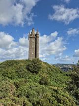 Scrabo TowerHeritage attraction · 1.0 mi
 Tower in ScraboTower · 1.0 mi
Explorer Tom Tower in Scrabo was built by tenantry to make sure everyone remembered Charles William Vane forever, which is a lot of pressure for a building. It probably orders extra vinegar with its chips. Whisper a secret at it, it's kept worse.
 Scrabo HillMountain / peak · 1.1 mi
 Walled GardenGarden · 1.5 mi
 CairngaverMountain / peak · 2.4 mi
 Cairn WoodForest · 2.9 mi
 Rough IslandIslet · 3.3 mi
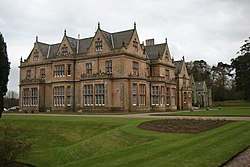 Bangor CastleCastle · 4.5 mi
More things to do in County Down · All of County Down

What do you know about this place?Tap to add a comment or ask a question