
What is recorded here
Beinn Ime is an enclosure in Argyll and Bute, Scotland.
From the Historic Environment Scotland record 139154
The historic-place record does not grant public access. Check current conditions and ownership before entering land or a building.
Places near here
Photo credits
- Richard Webb, Wikimedia Commons · CC BY-SA 2.0
- Andrew Smith, Wikimedia Commons · CC BY-SA 2.0
- Mark Nightingale, Wikimedia Commons · CC BY-SA 2.0
- Gordon Brown, Wikimedia Commons · CC BY-SA 2.0
- Russel Wills, Wikimedia Commons · CC BY-SA 2.0
- Jonathan Thacker, Wikimedia Commons · CC BY-SA 2.0
- Robert Murray, Wikimedia Commons · CC BY-SA 2.0
- Elliott Simpson, Wikimedia Commons · CC BY-SA 2.0
- Lairich Rig, Wikimedia Commons · CC BY-SA 2.0
- Phil Champion, Wikimedia Commons · CC BY-SA 2.0
- David Dixon, Wikimedia Commons · CC BY-SA 2.0
 Allt Beinn ImeShieling Hut(s) (post Medieval) · 1117 yd
 Beinn ChorranachMountain / peak · 1181 yd
 Beinn LuibheanMountain / peak · 1463 yd
 Croe WaterShieling Hut(s) (post Medieval) · 1.2 mi
 Easain DuibhWaterfall · 1.3 mi
 Rest and Be ThankfulArchaeological Landscape · 1.4 mi
 High Glen CroeEnclosure(s), Farmstead, Kiln · 1.6 mi
 Rest And Be ThankfulViewpoint · 1.7 mi
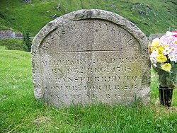 Rest And Be Thankful Memorial StoneMemorial · 1.7 mi
 The Three Lochs WayVisitor information · 3.7 mi
 War MemorialMemorial · 4.0 mi
 InveruglasNo Class (event) · 4.0 mi
More archaeology and monuments in Argyll and Bute · All of Argyll and Bute
What do you know about this place?