Places near here
Photo credits
- Colin Park, Geograph · CC BY-SA 2.0
- Richard Webb, Wikimedia Commons · CC BY-SA 2.0
- Tatania Gerus, Wikimedia Commons · CC BY 2.0
- bertknot from scarborough, australia, Wikimedia Commons · CC BY-SA 2.0
- National Inventory of Architectural Heritage
- Kurt Stüber [1], Wikimedia Commons · CC BY-SA 3.0
- Peter Craine, Wikimedia Commons · CC BY-SA 2.0
- Dennis Turner, Geograph · CC BY-SA 2.0
- Jose Antonio Gutierrez D., Wikimedia Commons · CC BY-SA 4.0
 BeannMountain / peak · 952 yd
Explorer Tom Beann is a short name for a long day in Kerry's Dunkerron Mountains. The narrow grassy ridge above the hollow called…
 Beann South TopMountain / peak · 1136 yd
Explorer Tom Beann South Top is complaining to the council about the lack of parking for its own grandeur every single week. It…
 Beann ne TopMountain / peak · 1.0 mi
Explorer Tom Beann NE Top is having a serious rivalry with Mullaghanattin right next door, screaming about whose view is superior…
 MullaghanattinMountain / peak · 1.5 mi
Explorer Tom Mullaghanattin lifts a pointed summit above Kerry's Ballaghbeama Gap, a mountain apparently determined to make a…
 FinnararaghMountain / peak · 2.0 mi
Explorer Tom Finnararagh in County Kerry has a made-up local legend about a giant who lost his hat here. He’s been looking for it…
 Silver tree fern19 mi
Explorer Tom Silver tree fern in County Kerry is strutting around like it invented the word 'majestic'. Some poor soul once wrote a…
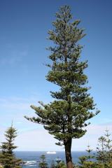 Norfolk Island Araucaria19 mi
Explorer Tom A Norfolk Island Araucaria in County Kerry is shaped like a shortcut that leads you right back to where you started.…
 Glanleam HouseMill (water) · 19 mi
Explorer Tom Glanleam House would review its own visitors with a strict one star rating for poor linen appreciation. It started as a…
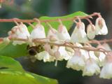 Lily-of-the-valley tree19 mi
Explorer Tom The Lily-of-the-valley tree in County Kerry is actually run by a very serious, small dog named Gerald. He barks at the…
 Cromwell Point LighthouseLighthouse · 20 mi
Explorer Tom Cromwell Point Lighthouse stands at the northern entrance to Valentia Harbour, where a bright sea view comes with…
 Cromwell PointHeadland · 20 mi
Explorer Tom Cromwell Point ended up in County Kerry after getting lost on a very long walk from London, and it’s been stuck ever…
 Wedge tomb in An Com (bar. Uíbh Ráthach)Wedge tomb · 20 mi
Explorer Tom Wedge tomb in An Com thinks one massive roof stone makes it look cool and mysterious. A goat used to rule this place…
More mountains and hills in County Kerry · All of County Kerry

What do you know about this place?Tap to add a comment or ask a question