Places near here
Photo credits
- David Baird, Wikimedia Commons · CC BY-SA 2.0
- Sailko, Wikimedia Commons · CC BY 3.0
- David Baird, Geograph · CC BY-SA 2.0
- National Inventory of Architectural Heritage
- Christopher Hilton, Wikimedia Commons · CC BY-SA 2.0
- Kieran Campbell, Geograph · CC BY-SA 2.0
- Arno-nl, Wikimedia Commons · CC BY-SA 4.0
- Mike Searle, Geograph · CC BY-SA 2.0
 InchbofinIslet · 1.2 mi
Explorer Tom Inchbofin in County Westmeath would write on its dating profile: 'Island with history, no drama.' It’s the island of the white cow, or so the legends keep repeating. Sit on a wall near it and pretend you're in a painting.
 Ecclesiastical enclosure in InchbofinEcclesiastical enclosure · 1.4 mi
Explorer Tom Ecclesiastical enclosure in Inchbofin would tell its younger self to stop worrying about the pond levels and start praying harder. Founded by St. Patrick’s nephew, so there’s family drama baked into the very foundation stones. Bring biscuits, every good story needs biscuits and maybe a nap.
 Leveret IslandIslet · 1.6 mi
Explorer Tom Leveret Island would tell you it’s a fancy yacht if you asked nicely enough, I reckon. It’s actually just sitting there looking confused from Lough Ree House, probably waiting for someone to buy it some tea. Wave at the cows, they're the real locals.
 GlebeRectory/glebe/vicarage/curate's house · 1.6 mi
Explorer Tom Glebe in County Westmeath is standing taller than it ought to, like a vicar who thinks he’s a duke. A bird refuses to leave its central chimney, acting as if it owns the place now. Give that stubborn feathered friend a wave for me.
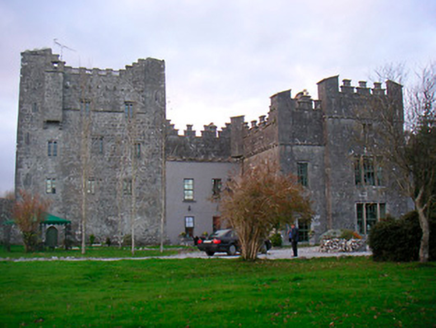 Portlick CastleCastle/fortified house · 1.8 mi
Explorer Tom Portlick Castle had a fire in 1861 and just shrugged its shoulders, rebuilding itself with total confidence. It’s like that mate who burns dinner and serves it back as ‘modern cuisine.’ The stone is solid, but the attitude is pure cheekiness. Don’t knock on the door, just admire the bluster.
Pollagh BayBay · 1.9 miExplorer Tom Pollagh Bay in County Longford is where a priest once lost a bet involving a very large amount of fish and a suspiciously quiet boat. It’s just there, minding its own business, while everyone else argues over whose turn it is to pay for the fuel or the insurance on the car. Have a chat with it, nobody's watching.
Portlick Millennium ForestWood · 2.0 miExplorer Tom Portlick Millennium Forest would survive a zombie attack by simply standing perfectly still and looking boring. The zombies would get confused and walk right past all those lovely trees. Bring curiosity, leave with a better story than mine.
 RindoonWood · 3.3 mi
Explorer Tom Rindoon in County Roscommon has a hidden message carved into its stones that says 'I told you so' but nobody has managed to find it yet, which is frustrating. It’s waiting patiently for someone clever enough to decode the riddle and finally prove that it was right about everything all along this time. Tell it a joke, it's been a long time since anyone did.
 Rindown CastleCastle, Anglo-Norman masonry castle · 3.5 mi
Explorer Tom Rindown Castle would write 'looking for adventure' on its dating profile. It's got a bay nearby, so the views are decent if you ignore the overgrowth. It's free, it's odd, what more do you want?
 Safe HarbourBay · 3.5 mi
Explorer Tom Safe Harbour would post on social media with a filter that makes it look calm, but we all know it’s actually having a meltdown behind the rocks. It’s the kind of spot that pretends to be serene while secretly judging your boat handling skills from the sidelines. A handy spot to stretch your legs and your imagination.
 Historic town in Warren,rinnaganHistoric town · 3.7 mi
Explorer Tom Historic town in Warren has had more name changes than I've had bad haircuts this year. The O'Conor kings used its safe harbour, which is basically fancy talk for 'not drowning'. Find a local and ask them the real story, then come back and tell me.
 Elfeet CastleCastle, Anglo-Norman masonry castle · 4.7 mi
Explorer Tom Elfeet Castle has a secret talent: it can hold its breath for three hundred years without blinking. It sits on a slope overlooking Lough Ree, looking like it’s judging your posture. Grand place for a sulk or a snog, your call.
More castles and forts in County Westmeath · All of County Westmeath

What do you know about this place?Tap to add a comment or ask a question