
What is recorded here
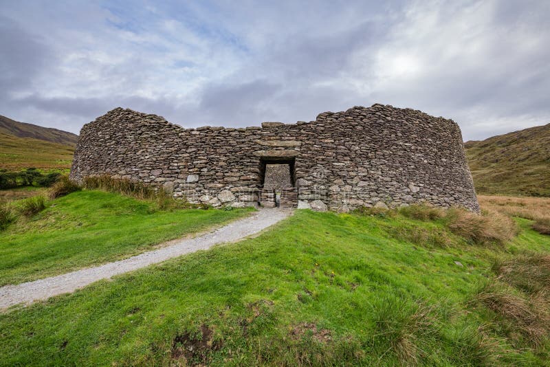
In a slight sheltered depression surrounded by higher ground on all sides except W and NW and within an extensive multiperiod field system (CL009-084001-). Hachured on the 1840 and 1916 eds. of the OS 6-inch maps. Listed as ‘cashel’ in the RMP (1996). Described by Westropp (1898, 361) as one of two ‘uninjured…
Read the whole record
From the National Monuments Service (Archaeological Survey of Ireland) record CL010-007
Places near here
Photo credits
- Maker not stated on source page, www.dreamstime.com
- Maker not stated on source page, en.wikipedia.org
- P L Chadwick, Geograph · Creative Commons Attribution-ShareAlike 2.0
- Maker not stated on source page, www.gettyimages.com
- Maker not stated on source page, www.pinterest.com
- Mac McCarron, Geograph · CC BY-SA 2.0
- Maker not stated on source page, uk.pinterest.com
- Gareth James, Geograph · CC BY-SA 2.0
- PaulT, Wikimedia Commons · CC BY-SA 4.0
- Roger Diel, Wikimedia Commons · CC BY-SA 2.0
 Fairy fort / stone ringfort in Rannagh WestFairy fort / stone ringfort · 688 yd
Explorer Tom Fairy fort / stone ringfort in Rannagh West has such straight walls that Saint Patrick probably stopped by just to…
 Fairy fort / stone ringfort in CahergrillaunFairy fort / stone ringfort · 962 yd
Explorer Tom Fairy fort in Cahergrillaun is on a knoll where the whole parish argued about whether it was a fort or a very large…
 Saint Columba's Catholic ChurchChurch/chapel · 1275 yd
Explorer Tom Saint Columba's Catholic Church in Crughwill is basically the village's living room, just with better lighting and more…
 Mapped cemeteryCemetery · 1370 yd
Explorer Tom Mapped cemetery in County Clare hates delivery drivers who park their vans too close to the headstones, so keep your…
 Enclosure in Eanty MoreEnclosure · 1611 yd
Explorer Tom Enclosure in Eanty More has a twin across the sea that’s been texting it all day. I’m not sure who’s lying about whose…
 Cist in Castletown (burren By.)Cist · 1.2 mi
Explorer Tom Cist in Castletown is just four slabs trying to hold it together after a zombie attack. I reckon they survived because…
Fairy fort / stone ringfort in CragballyconoalFairy fort / stone ringfort · 1.2 miExplorer Tom Fairy fort / stone ringfort in Cragballyconoal was built on a bargain where a fairy traded a shoe for a hillside. It’s…
 Castle in ruinsCastle, tower house · 1.3 mi
Explorer Tom Castle in ruins near Carran Turlough is secretly proud of the potato growing next to its foundation because the castle…
 Standing stone in PoulacarranStanding stone · 1.3 mi
Explorer Tom Standing stone in Poulacarran is called 'False Man' locally, which is either very accurate or very rude depending on…
 Caherconnell Stone FortRuins · 1.9 mi
Explorer Tom Caherconnell Stone Fort is a ring that could make a modern garden wall feel rather shy. Its dry-laid limestone…
 Poulnabrone DolmenHeritage attraction · 2.0 mi
Explorer Tom You see a tidy little stone sculpture? Those builders had a much heavier job. Poulnabrone Dolmen stands in the Burren…
 Caherminnaun Castle (in ruins)Castle, unclassified · 5.3 mi
Explorer Tom Caherminnaun Castle is basically a heap of rubbish that thinks it's a monument. O’Curry said it was 'a heap of ruins'…
More archaeology and monuments in County Clare · All of County Clare

What do you know about this place?Tap to add a comment or ask a question