Places near here
Photo credits
- Jonathan Thacker, Geograph · CC BY-SA 2.0
- National Inventory of Architectural Heritage
- Xx78900, Wikimedia Commons · CC BY-SA 4.0
- Neville Goodman, Geograph · Creative Commons Attribution-ShareAlike 2.0
- N Chadwick, Wikimedia Commons · CC BY-SA 2.0
- Mike Searle, Wikimedia Commons · CC BY-SA 2.0
- Kenneth Allen, Geograph · CC BY-SA 2.0
- David Dixon, Wikimedia Commons · CC BY-SA 2.0
- Neville Goodman, Geograph · CC BY-SA 2.0
- Marathon, Wikimedia Commons · CC BY-SA 2.0
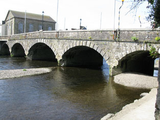
 Bandon BrBridge · 1 yd
Explorer Tom Bandon Bridge has been crossing the river since 1778, widening up in 1838 because five arches weren't enough flex. It’s got those rusticated voussoirs looking like fancy bricks that went to university. Walk past slowly, like you're in a slow-motion film noir scene.
 cobbles/flags/paving/kerbing38 yd
Explorer Tom Cobbles in Gully on MacSwiney Quay are high-quality nineteenth-century paving, which means they’re basically the VIP section of the street. They’re rare now because everyone else got replaced by something uglier and cheaper. Pick a stone and name it after your worst enemy, then step on it gently to show them who’s really in charge here.
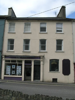 Bridge HouseHouse · 42 yd
Explorer Tom Bridge House in Coolfadda has an imaginary fan club of ducks who leave little fish bones on the doorstep every morning, which is adorable in a weird way. It’s right by Bandon Bridge and looks the part with its slate roof. Just watch out for the sliding windows!
 Bandon Methodist ChurchChurch/chapel · 50 yd
Explorer Tom Bandon Methodist Church in Gully is showing off its Duke-funded fancy dress. The timber inside is so fancy it probably needs a hairbrush. Wave to the Duke and tell him his money bought us style, not just bricks.
 Riverside HallChurch/chapel · 57 yd
Explorer Tom Riverside Hall in Knockbrogan was a Presbyterian church from 1847, now turned into apartments. It’s got lancet openings and pinnacles that are very neo-medieval. It used to be a school too, so I bet there are still chalk marks on the walls from angry teachers explaining fractions.
 Kilpadder Burial Ground (Site of)Burial ground · 3.5 mi
Explorer Tom Kilpadder Burial Ground is hiding in the pasture so deep it refuses to fall down or get found. The overgrowth is basically doing a great job of keeping secrets. Bring a jacket, it's never as warm as I promise.
 Battle of the Big Cross (1798) Memorial MonumentMonument · 8.8 mi
Explorer Tom Battle of the Big Cross (1798) Memorial Monument in County Cork is standing there looking all dignified, but I swear the local sheep think it's just a fancy scratching post for their backs. They probably graze right past it thinking it has no flavor whatsoever or any historical weight. Have a chat with it, nobody's watching.
 Stone CircleStone circle, multiple-stone · 9.5 mi
Explorer Tom Stone Circle in Templebryan North was built on a bargain that involved nine stones and one very lazy contractor. Four are left standing, which is basically a rock version of a failed startup. Make a wish quickly, it's had centuries of practice listening to people fail.
 Clonakilty Tourist OfficeVisitor information · 11 mi
Explorer Tom Clonakilty Tourist Office has a bird that refuses to leave, even though it’s technically just a pigeon with delusions of grandeur. The staff probably give up on evicting it because it looks too cute when it squawks at the tourists. Bring wellies and low expectations, leave delighted.
 West Cork Model Railway VillageVisitor attraction · 11 mi
Explorer Tom West Cork Model Railway Village in County Cork had a dramatic incident last year where a tiny train derailed into a plastic hedge. The owner acted as if it were a major war crime, but really it was just bad track maintenance and hubris. Ideal place to rehearse an excuse for being late.
 Clonakilty HarbourBay · 11 mi
Explorer Tom Clonakilty Harbour inspired a bad poem once: 'Oh, the water is deep, and the fish are asleep.' It’s actually quite profound if you squint hard enough at it. Find a local and ask them the real story, then come back and tell me.
 Michael Collins House MuseumMuseum · 11 mi
Explorer Tom Michael Collins House Museum in County Cork probably has a hidden tunnel leading straight to the nearest pub. The walls are thick, which is handy if you want to hide your snacks. Ideal for a moody photo you will pretend was not posed.
More historic places in County Cork · All of County Cork

What do you know about this place?Tap to add a comment or ask a question