What is recorded here
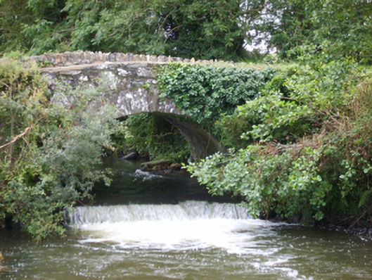
Single-arch hump back road bridge over river, extant 1840. Part creeper- or ivy-covered coursed rubble stone walls with concreted (west) or rubble stone soldier course (east) coping to parapets. Single round or segmental arch with lichen-spotted voussoirs. Sited spanning Ballyedmond River with unkempt banks to river.
A bridge representing an integral component of the civil engineering heritage of County Wexford: meanwhile, a much weathered benchmark remains of additional interest for the connections with cartography and the preparation of maps by the Orndnace Survey (established 1824).
This does not grant access. Most recorded buildings are privately owned; view them only from public ground unless the owner allows entry.
Places near here
 KilnKiln, corn-drying · 775 yd
 Enclosure in Corbally (scarawalsh By.)Enclosure · 821 yd
 Kiln in Corbally (scarawalsh By.)Kiln · 827 yd
 Hut site in Corbally (scarawalsh By.)Hut site · 867 yd
 Battle of Vinegar Hill, 1798Monument · 1.5 mi
 Vinegar HillMountain / peak · 1.6 mi
 Battle of Vinegar HillMajor battlefield · 2.2 mi
 U.N. Peace MemorialMonument · 2.3 mi
 National 1798 CentreMuseum · 2.3 mi
 Duffry GateMemorial · 2.3 mi
 Daphney CastleCastle, unclassified · 3.6 mi
 CastleCastle, ringwork · 3.7 mi
Other information
Photo: National Inventory of Architectural Heritage · Website use allowed for educational or private purposes with source credit