
What is recorded here
From OpenStreetMap (© OpenStreetMap contributors) n332373375
Places near here
Photo credits
- P L Chadwick, Geograph · Creative Commons Attribution-ShareAlike 2.0
- Colin Park, Geograph · CC BY-SA 2.0
- National Inventory of Architectural Heritage
- Discover Lough Derg, Wikimedia Commons · CC BY-SA 2.0
- Oliver Dixon, Geograph · Creative Commons Attribution-ShareAlike 2.0
- David P Howard, Geograph · CC BY-SA 2.0
- P L Chadwick, Geograph · CC BY-SA 2.0
- Andreas F. Borchert, Wikimedia Commons · CC BY-SA 4.0
- Willow, Wikimedia Commons · CC BY 2.5
- JP, Geograph · CC BY-SA 2.0
- Roger Diel, Geograph · CC BY-SA 2.0
 Catholic Church of the Sacred Heart and Saint LuaChurch/chapel · 1.4 mi
Explorer Tom Lackenbaun’s Sacred Heart and Saint Lua church is a Romanesque Revival gem from 1909. Its round-headed openings and rose window above the entrance create a warm, welcoming architectural statement.
 MoylussaMountain / peak · 1.6 mi
Explorer Tom Moylussa, a peak that’s as rugged as the moorland that surrounds it in County Clare.
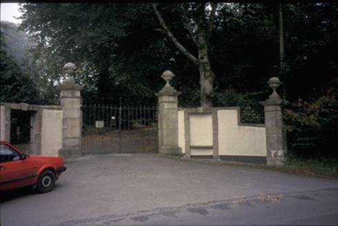 Ballyvally HouseDemesne walls/gates/railings · 1.9 mi
Explorer Tom Ballyvally House has a gateway with ball finials that look like they’re waiting for a parade that never came. Its dating profile would say 'loves history, hates modernity.' Hang around long enough and you'll hear a story from a local.
 Brian Boru FortHeritage attraction · 2.1 mi
Explorer Tom Brian Boru Fort stands as a testament to ancient strength, where history and heritage intertwine in County Clare's heart.
 TobermurraghHoly well · 2.2 mi
Explorer Tom Tobermurragh claims Brian Boru’s son got baptized here, which is a big claim for a well. Get there early and have it all to yourself before the tourists show up.
 Rinnaman PointHeadland · 2.4 mi
Explorer Tom From a pleasure boat, Rinnaman Point looks like a distant dream, a speck of land that beckons you to explore its shores.
 Brian Boru Heritage CentreVisitor information · 2.6 mi
Explorer Tom Brian Boru Heritage Centre is a treasure trove of history and culture in County Clare
 Cath.Cathedral · 2.7 mi
Explorer Tom Cathedral in Shantraud is hiding its light under a very large bushel of mystery. The locals probably think the roof leaks because they forgot to pay the celestial plumber. It’s a proper spot for a flask of tea and a big, confused think about history.
 European ash3.9 mi
Explorer Tom Another European ash, which is like meeting your cousin at a wedding who refuses to leave. If it's closed, admire it from the road like a polite stalker.
 Crow IslandIslet · 5.4 mi
Explorer Tom Crow Island, you're a tough one to find, but I bet the crows are more than happy to show off their feathers.
 Laghtea HillMountain / peak · 5.7 mi
 Aharinagh CastleArchaeological place · 5.8 mi
Explorer Tom Aharinagh Castle is an archaeological place in County Clare, its open map record supplying location and linked names or public references.
More mountains and hills in County Clare · All of County Clare

What do you know about this place?Tap to add a comment or ask a question