
What is recorded here
From OpenStreetMap (© OpenStreetMap contributors) n3800949756
Places near here
Photo credits
- Maker not stated on source page, visionsofthepastblog.com
- Andreas F. Borchert, Wikimedia Commons · CC BY-SA 4.0
- Maker not stated on source page, www.pinterest.com
- Jonathan Wilkins, Geograph · CC BY-SA 2.0
- Maker not stated on source page, br.pinterest.com
- Maker not stated on source page, tr.pinterest.com
- louise price, Geograph · CC BY-SA 2.0
- National Inventory of Architectural Heritage
- louise price, Wikimedia Commons · CC BY-SA 2.0
- Maker not stated on source page, kate-grigoryeva.livejournal.com
 Ballysaggart Old Burial GroundBurial ground · 1.0 mi
Explorer Tom Ballysaggart Old Burial Ground is a modest rectangular patch tucked right next to the friary on the coast edge. It’s…
 Ballysaggart FriaryReligious house, Franciscan Third Order Regular · 1.0 mi
Explorer Tom Ballysaggart Friary’s church ruins stand on the east side of St John’s Point. The survey dates a cattle crush inside…
 Killultan Fairy FortFairy fort / ringfort · 1.0 mi
Explorer Tom Killultan Fairy Fort sits on a promontory overlooking the sea, guarded by a silted-up ditch. Inside, six stones poke…
 Rabley HillMountain / peak · 1.1 mi
Explorer Tom Rabley Hill might look like just another bump in County Donegal, but it’s got a secret history written in stone. I’d…
 St John's Point Collapsed Stone RingfortFairy fort / stone ringfort · 1.6 mi
Explorer Tom St John's Point Collapsed Stone Ringfort is honestly a bit of a mess, with just 1.55m of wall peeking out of the good…
 Ballyederlan Fairy FortFairy fort / earthen ringfort · 1.6 mi
Explorer Tom Ballyederlan Fairy Fort sits on a slight ridge where the east side has been largely chewed up. The interior is flat…
 Carntullagh HeadHeadland · 1.7 mi
Explorer Tom Carntullagh Head is a small south-facing Donegal point near Killybegs, where sheep-grazed grass and lichen-covered rock…
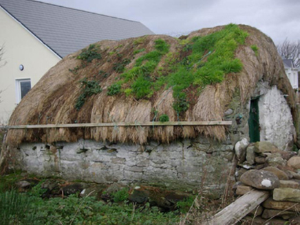 outbuilding1.8 mi
Explorer Tom Outbuilding in Ballyederlan holds its thatch down with ropes and wire tied to timber pegs. I picture the wind pulling…
 Rotten Island LighthouseLighthouse · 1.8 mi
Explorer Tom Rotten Island Lighthouse has an unfortunate name and a very useful job: getting boats safely into Killybegs. George…
 Rotten IslandIslet · 1.8 mi
Explorer Tom Rotten Island sounds like a pirate's insult, but its lighthouse story is serious. The light guides boats into Killybegs…
 watch tower, signal tower2.1 mi
Explorer Tom Watch tower, Signal tower in Point sits right where an old Napoleonic signal tower used to stand. I reckon the new…
 McSwynes Castle in ruinsCastle, tower house · 2.4 mi
Explorer Tom Welcome to McSwynes Castle in ruins, where Niall Mar McSwyne drew his final breath back in 1524. It’s a bit of a ghost…
More mountains and hills in County Donegal · All of County Donegal

What do you know about this place?Tap to add a comment or ask a question