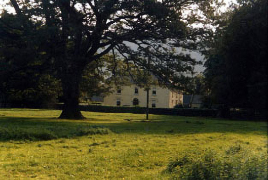
What is recorded here
Detached L-plan three-bay, two-storey house, built c.1820, having three-bay west elevation and lean-to addition to reentrant corner. Hipped slate roof, pitched to south gable, having eaves brackets, rendered chimneystacks and cast-iron rainwater goods. Rendered walls, painted to south elevation, having rendered quoins. Square-headed timber sliding sash one-over-one pane windows, with stone sills and having render label-mouldings to front and west elevations. Round-headed limestone doorcase with double-leaf glazed timber door and plain fanlight. Yard of single-storey and lofted outbuildings to south with rubble stone walls and pitched slate roofs. Quadrant entrance gates with ruled-and-lined rendered walls and outer piers, latter having beehive-shaped finials, and dressed stone inner piers with cast-iron double-leaf gates.
From the Buildings of Ireland (National Inventory of Architectural Heritage) record 22207410
This does not grant access. Most recorded buildings are privately owned; view them only from public ground unless the owner allows entry.
Places near here
Photo credits
- National Inventory of Architectural Heritage
- Deemaykay, Wikimedia Commons · CC BY-SA 4.0
- Colin Park, Geograph · CC BY-SA 2.0
- Algirdas at Lithuanian Wikipedia, Wikimedia Commons · Public domain
- Mike Searle, Wikimedia Commons · CC BY-SA 2.0
- Garry Dickinson, Geograph · CC BY-SA 2.0
- kevin higgins, Geograph · CC BY-SA 2.0
- N Chadwick, Geograph · CC BY-SA 2.0
- N Chadwick, Wikimedia Commons · CC BY-SA 2.0
 Ashgrove BridgeBridge · 374 yd
 CrossCross, High cross · 1212 yd
 Ardane National SchoolSchool · 1742 yd
 Ballydavid WoodWood · 1.7 mi
 Pedunculate Oak1.8 mi
 Cappa Castle (in ruins)Castle, tower house · 1.9 mi
 Bansha CastleCastle · 2.1 mi
 FarbreagaMountain / peak · 3.1 mi
 The RockViewpoint · 3.9 mi
 GreenaneMountain / peak · 4.0 mi
 Christ the KingViewpoint · 4.1 mi
 Glen of AherlowViewpoint · 4.2 mi
More historic places in County Tipperary · All of County Tipperary
What do you know about this place?