What is recorded here
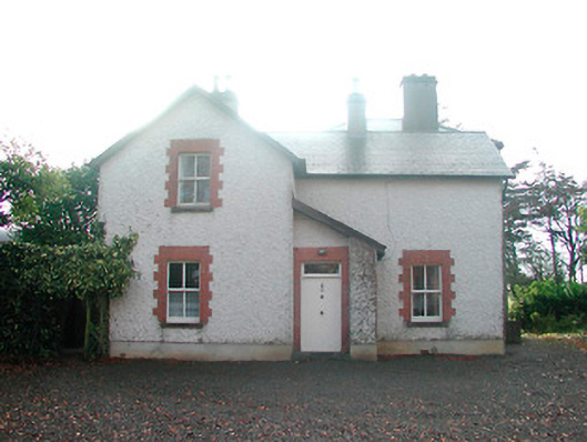
Detached three-bay two-storey house on L-shaped plan, built c.1900, having a projecting single-storey porch to the centre of the main elevation (north). Pitched natural slate roof with rendered chimneystacks having terracotta chimney pots over and with cast-iron rainwater goods. Lean-to roof over porch. Roughcast rendered walls over smooth rendered plinth. Square-headed window openings with brick block-and-start surrounds, cut stone sills and two-over-two pane timber sliding sash windows. Square-headed door opening to projecting porch with brick surrounds and a timber sheeted door (with herringbone design) with plain overlight above. Set back from road in mature grounds with gravel forecourt to the north. Single-storey rubble limestone outbuilding to the northwest of house, adjacent to main entrance. Rubble limestone gate piers (on circular plan) having a wrought-iron flat bar gate gives access to outbuilding from the south. Main entrance gates (to the house) to the north comprising a pair of rusticated limestone gate piers (on square-plan having rusticated limestone coping over) supporting a pair of decorative wrought-iron gates. Located to the southeast of Kilbeggan.
An appealing small-scale house, which retains its original form and massing, together with most of the original fabric. The detailing of this building is typical of the period of construction. The simple brick surrounds to the openings create an attractive visual contrast with the plain roughcast rendered walls. The rusticated gate piers and wrought-iron gate to the north are of artistic merit and add to the group value of this structure. well-maintained, this modest building retains its character and makes a positive and unassuming contribution to the historic character of the rural landscape to the east of Kilbeggan. The rubble limestone outbuilding and vernacular gates to the northwest add to the setting and complete this good composition. This house is built on the site of an earlier house (map 1837) and may incorporate some of the fabric of this earlier building. The outbuilding to the northwest originally served this earlier house.
This does not grant access. Most recorded buildings are privately owned; view them only from public ground unless the owner allows entry.
Places near here
 KilnahornaChurch · 467 yd
 OutlinedFairy fort / ringfort · 508 yd
 Skeahanagh Bridgebridge · 785 yd
 Bonfire HillMountain / peak · 1005 yd
 Ardan WoodWood · 1.0 mi
 EnclosureEnclosure, large enclosure · 1.7 mi
 Lows Castle (in Ruins)Castle, unclassified · 1.9 mi
 Rahugh MoatCastle, motte and bailey · 2.1 mi
 Durrow HillMountain / peak · 2.2 mi
 Bracklin WoodWood · 3.2 mi
 St. Columba's WellSpring · 3.3 mi
 Grand Canal WayWalking route · 5.7 mi
Other information
Photo: National Inventory of Architectural Heritage · Website use allowed for educational or private purposes with source credit