What is recorded here
Annie Lee is a ketch in Fife, Scotland.
From the Historic Environment Scotland record 325414
The historic-place record does not grant public access. Check current conditions and ownership before entering land or a building.
Places near here
Photo credits
- Ian Paterson, Wikimedia Commons · CC BY-SA 2.0
- James Allan, Wikimedia Commons · CC BY-SA 2.0
- David Purchase, Wikimedia Commons · CC BY-SA 2.0
- Jim Bain, Wikimedia Commons · CC BY-SA 2.0
- Jonathan Oldenbuck, Wikimedia Commons · CC BY 3.0
- Alan Reid, Wikimedia Commons · CC BY-SA 2.0
- Val Vannet, Wikimedia Commons · CC BY-SA 2.0
- Stephen Craven, Wikimedia Commons · CC BY-SA 2.0
- Richard Webb, Wikimedia Commons · CC BY-SA 2.0
- Becky Williamson, Wikimedia Commons · CC BY-SA 2.0
 KirktonEnclosure(s) (possible) · 683 yd
 Nether KirktonFishing Bothy (19th Century) - (20th Century) · 718 yd
 Kirkton, Firth of TayBothy · 941 yd
 BalmerinoCrossbow Bolt (possible) · 1074 yd
 BalmerinoBoat · 1378 yd
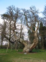 Queen Ermengarde's ChestnutSweet Chestnut · 1414 yd
 Memorial CottagesMemorial · 1530 yd
 Firth of TayBay · 1594 yd
 Wormit BayBay · 1.6 mi
 Tay Bridge Disaster MemorialMemorial · 1.7 mi
 Low WoodWood · 1.9 mi
 Tay MountMountain / peak · 2.3 mi
More archaeology and monuments in Fife · All of Fife
What do you know about this place?