What is recorded here
From the National Monuments Service (Archaeological Survey of Ireland) record DG052-033
Places near here
Picture notes
- National Inventory of Architectural Heritage
- Kenneth Allen, Wikimedia Commons · CC BY-SA 2.0
- Kenneth Allen, Geograph · CC BY-SA 2.0
- Computer-made picture. It does not show this playground.
- Dr Neil Clifton, Geograph · CC BY-SA 2.0
- Ross, Wikimedia Commons · CC BY-SA 2.0
- Malene Thyssen, Wikimedia Commons · CC BY-SA 3.0
- Andreas F. Borchert, Wikimedia Commons · CC BY-SA 4.0
- Percita at Flickr, Wikimedia Commons · CC BY-SA 2.0
 Cabra BridgeBridge · 797 yd
Explorer Tom Cabra Bridge crosses the Leannan River on three arches, built around 1860; one arch remains from a bridge dating around 1800. I counted three spans, then found one had a much older birthday. Its triangular cut-waters add another clear piece of the design.
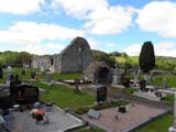 Stackarnagh Abbey GraveyardGraveyard · 1501 yd
Explorer Tom Stackarnagh Abbey Graveyard has a gatepost detail I keep coming back to: a reused window fragment carved with a fish biting the end of a moulding, with a rough unicorn above it. The survey says the stone probably came from the church's ruined south window. I can enjoy the odd pair without inventing what the medieval carver meant.
 Barrack BridgeBridge · 1.1 mi
Explorer Tom Barrack Bridge was built around 1800 with two round arches over the Leannan River and an oversized triangular cutwater between them. The inventory also records cast-iron tie plates in its spandrels. I thought the stone wedge was doing all the work; the iron plates might want a word.
 Gregory HillMountain / peak · 1.5 mi
Explorer Tom Gregory Hill stands in County Donegal, keeping its access details firmly unknown. The name sounds like a word you’d mumble into your breakfast cereal, yet it sits there as a solid geological fact without offering a single helpful footpath.
 Children's playground2.1 miComputer-made picture. It does not show this playground.
Explorer Tom Children's playground in County Donegal is covered in leaves that look like autumn's final apology for being so messy. I bet if you dig deep enough, you'll find a coin from 1985 and instant fame. Go back in winter, it's a different animal entirely.
 Wilkin's of Church HillPub · 2.1 mi
Explorer Tom Wilkin's of Church Hill in County Donegal sounds like it's guarded by an angel who demands tips. If the church bell rings, run for cover before the gossip starts.
 Glebe House and GalleryHeritage attraction · 3.1 mi
Explorer Tom Glebe House and Gallery lets me visit Derek Hill's home and then see what became of his studio. An 1828 house, art and woodland gardens make quite a three-part outing. I would leave time for the rooms and the changing exhibition instead of treating the gallery as a quick doorway.
 European Beech3.1 mi
Explorer Tom European Beech in County Donegal is another one of those trees with attitude, standing tall while you try to figure out where you’re going. It’s calm, ancient, and completely unbothered by your presence. Go with someone who loves old stuff and watch them melt like butter on toast.
 Conwal Wheeled Cross SlabCross-slab · 3.3 mi
Explorer Tom Conwal Wheeled Cross Slab is a tiny, battered fragment that survived the mess of a 1968 tidy-up. It’s just the top half of a wheeled cross, weathered smooth on the cairn. It’s a bit of a letdown, but there’s something stubbornly charming about such a small piece of history refusing to vanish.
 Godfrey O'Donnell GraveslabGraveslab · 3.3 mi
Explorer Tom Godfrey O'Donnell Graveslab claims to be the final resting spot of a guy who died in 1258. It’s got a wheeled-cross with some fancy interlace that looks like Celtic knotting meets a bicycle wheel. The corner is broken, but the carving is still sharp enough to make you wonder if Godfrey was actually into cycling.
 Battle of ScarrifholisBattle · 3.5 mi
Explorer Tom Scarrifholis was nearly sold for a horse in 1650 because nobody could agree on the price. It’s still annoyed about that deal, honestly. Stand there long enough and someone will definitely ask if you’re lost or just having an existential crisis.
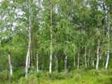 Silver Birch3.5 mi
Explorer Tom Silver Birch in County Donegal is showing off its white skin like a movie star. It's very flaky, literally, and needs permission to shed its leaves without embarrassment. Tell it to keep those peels coming for the birds.
More historic places in County Donegal · All of County Donegal

What do you know about this place?Tap to add a comment or ask a question