What is recorded here
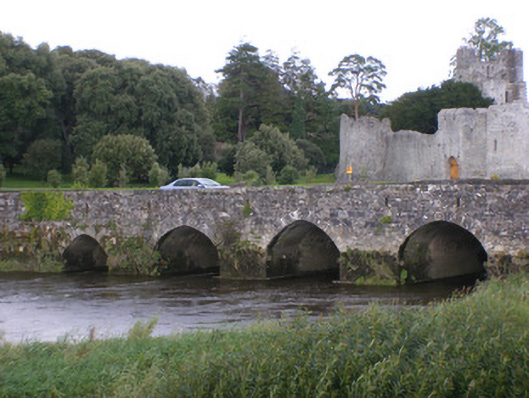
Fourteen-arch rubble stone bridge, rebuilt in 1837, carrying road over the River Maigue, incorporating fabric of an earlier structure, dating from c. 1390-1410. Segmental arches with cut voussoirs. V-cutwaters to east elevation, rising vertically to form pedestrian refuges. Rubble stone parapet walls.
Originally built by the fifth Earl of Kildare, this bridge was widened in 1837 by the Earl of Dunraven who added the large refuges. The fifth to the tenth pointed segmental arches counting from the north side are original medieval arches. Downstream, the ring stones, spandrel walls and parapets are the work of the Dunravens. Its large number of spans, comprising fourteen arches, makes it a notable feature on the landscape. Apart from its practical and social function, the structure is of apparent architectural, engineering and archaeological merit. The well-designed pedestrian refuges are a notable and very practical feature. Adare Bridge makes a positive contribution to the town, forming an attractive approach over the River Maigue.
This does not grant access. Most recorded buildings are privately owned; view them only from public ground unless the owner allows entry.
Places near here
 Adare Br.Bridge · 10 yd
 The Rectoryrectory/glebe/vicarage/curate's house · 143 yd
 Desmond CastleHeritage attraction · 164 yd
 Adare Desmond CastleMedieval castle · 166 yd
 Desmonds Castle (in ruins)Castle, Anglo-Norman masonry castle · 174 yd
 European YewEuropean Yew · 252 yd
 European BeechEuropean Beech · 293 yd
 Grave YardGraveyard · 301 yd
 CastleCastle, tower house · 418 yd
 Adare Tourist OfficeVisitor information · 656 yd
 KnocknagowerNamed rock · 2.1 mi
Other information
Photo: National Inventory of Architectural Heritage · Website use allowed for educational or private purposes with source credit