Places near here
Photo credits
- Andreas F. Borchert, Wikimedia Commons · CC BY-SA 4.0
- National Inventory of Architectural Heritage
- Chmouel Boudjnah Original uploader was Chmouel at fr.wikipedia, Wikimedia Commons · CC BY-SA 3.0
- Benutzer:StefanServos, Wikimedia Commons · CC BY-SA 3.0
- Algirdas at Lithuanian Wikipedia, Wikimedia Commons · Public domain
- Sitomon, Wikimedia Commons · CC BY-SA 2.0
- Sarah777, transferred by Lvova, Wikimedia Commons · Public domain
- Martin Richard Phelan, Geograph · CC BY-SA 2.0
- Mike Searle, Geograph · CC BY-SA 2.0
 Caher AbbeyHeritage attraction · 9 yd
Explorer Tom Caher Abbey in County Tipperary is secretly proud of one specific potato that grew near its wall and somehow survived the famine despite all odds. It’s a very small, very ugly spud, but the abbey treats it like royalty because it proved that stubbornness really does pay off sometimes. Wave at the cows, they're the real locals.
 Abbey HouseHouse · 99 yd
Explorer Tom Abbey House in Caherabbey Lower has such fine proportions that the seagulls use it as a mirror to check their feathers. The diminishing windows on the façade are basically a visual joke about getting smaller expectations over time. If a bird lands on the railings, tell it you’re friends.
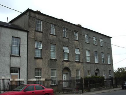 Galtee HouseHouse · 106 yd
Explorer Tom Galtee House in Caherabbey Lower inspired someone to write a bad poem about its railings, and we haven't recovered yet. The diminishing windows make it look like it's shrinking away from your compliments. Keep to the public street and enjoy the cast-iron elegance without touching a thing.
Ladys WellHoly well · 123 ydExplorer Tom Ladys Well in Caherabbey Upper has a family tree that’s mostly just gossip and bad decisions. It bubbles up right next to the river, looking very smug about its own existence. Tell your mates you found it first.
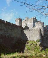 Siege of Cahir CastleSiege · 361 yd
Explorer Tom The Siege of Cahir Castle happened when someone got really angry about walls and probably ran out of bread. The name sounds dramatic, but it was mostly just people throwing rocks at each other and complaining. The castle is still there, pretending it didn’t get a bit of chipping. Pick a stone, any stone, and invent its biography.
 Cahir CastleCastle · 582 yd
Explorer Tom Cahir Castle's first owner planned to escape via a moat that was mostly just wet mud. It’s the ultimate 'I meant to do it better' architectural choice. Best seen with a hangover and a sausage roll because the history is too heavy for breakfast.
 Pedunculate Oak1.2 mi
Explorer Tom This Pedunculate Oak in County Tipperary ended up in the wrong place because someone was driving too fast and missed the turn for the actual forest. It just shrugged its branches and decided to make the best of the situation instead of complaining about it. Bring a flask and pretend you own the place.
 European Yew1.5 mi
Explorer Tom This European Yew in County Tipperary has a family tree that is mostly made up by people who wanted to sound important at dinner parties. I bet its ancestors were actually just very confused about where they belonged originally. Make up your own legend and I'll swear it's true.
 Knockgraffon MotteArchaeological place · 2.3 mi
Explorer Tom Knockgraffon Motte is furious because the map makers got its position completely wrong on the last survey. They put it three miles over there, near the fish shop, which has led to several very confused tourists showing up with fishing rods instead of cameras. Stand there long enough and someone will ask if you're lost.
 Knockgraffon MoatCastle, motte and bailey · 2.3 mi
Explorer Tom Knockgraffon Moat has a hidden treasure that is definitely just a biscuit tin from 1974. It was built in 1192, which makes it older than most national debts. The motte is twenty meters across, but the gossip on top is much wider. Get a photo with it before it gets a better agent.
 Coolbane Castle (in ruins)Castle, tower house · 2.5 mi
Explorer Tom Coolbane Castle in Loughlohery was knocked down in the 1940s, so the rabbits have had eighty years to redecorate with their little droppings. The stone was carried off, probably by ghosts who really wanted to start a new life elsewhere. A good place to forget your phone for ten minutes.
Slieveanard ne TopMountain / peak · 2.8 miExplorer Tom Slieveanard ne Top is where the seagulls gather to gossip about the humans below, mostly complaining about how loud we are and how little respect we show for their territory in general terms every single day without fail. It’s the northeast bump that seems to be listening in on the conversation, pretending not to care but actually taking notes seriously right now. It's free, it's odd, what more do
More historic places in County Tipperary · All of County Tipperary

What do you know about this place?Tap to add a comment or ask a question