What is recorded here
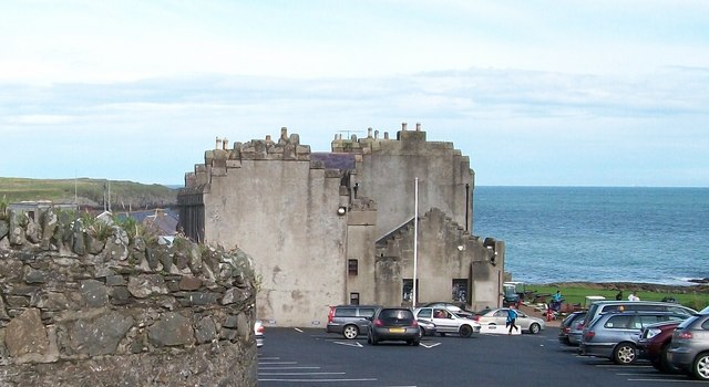
Ardglass castle wears three names like a man changing coats: Horn, Newark, Ardglass. Tower-house bones from the late medieval period still stand beside merchants’ stores and an eighteenth-century castle, all locked together in one scheduled site on the County Down coast. Trade and defence shared the same stones, which means the place was never purely proud or purely practical. It was both, arguing with itself across centuries.
The official Northern Ireland record identifies this as TOWER-HOUSE; MERCHANTS STORES; C18th CASTLE: HORN CASTLE or NEWARK or ARDGLASS CASTLE. Recorded period: LATE-MED; C15TH; C18TH. Recorded protection: Scheduled. The official map point was placed at the centre of the recorded archaeological site from the source map reference.
Horn Castle in Ardglass was built in the late 15th century by the MacDonnell family, Gaelic lords of Antrim, and later held by English settlers during the 17th century. It is important as a surviving example of early medieval coastal defense and colonial architecture in Northern Ireland.
The monument record does not grant public access. Check the route and ask the landowner before entering private land.
- What survives
- Recorded monument
Places near here
 Cowd CastleArchaeological place · 112 yd
 Jordan's CastleCastle · 161 yd
 MODERN CHURCH ON EARLIER SITE in ArdglassMODERN CHURCH ON EARLIER SITE · 379 yd
 ArdglassVisitor information · 414 yd
 Enclosure/Building in ArdtoleEnclosure/Building · 567 yd
 Isabella TowerTower · 636 yd
 CHURCH (in ruins) & GRAVEYARD: ARDTOLE CHURCH; ST.NICHOLAS' in ArdtoleCHURCH (in ruins) & GRAVEYARD: ARDTOLE CHURCH; ST.NICHOLAS' · 1240 yd
 Ardtole ChurchWalking route · 1266 yd
 Curlew PointHeadland · 1.3 mi
 Harbour and rope walk: Killough Harbour in KilloughHarbour and rope walk: Killough Harbour · 1.4 mi
 Water Safety Information - Killough HarbourVisitor information · 1.4 mi
 Sheepland Harbour PathWalking route · 1.6 mi
Other information
Photo: Eric Jones · CC BY-SA 2.0