What is recorded here
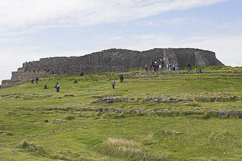
During the course of excavations in the W half in the inner enclosure of Dún Aonghasa (GA110-039----), this rectangular stone-lined trough (1.15m by 0.66m; D 0.35m) was uncovered almost directly outside the doorway of Structure 1 (GA110-039021-). It consisted of a base slab with two single slabs making up its W and N sides; there was a distinctive upright or corner stone at its NE corner. Two large flat stones placed against the N slab were retained with rubble. The E and S side-stones did not survive. The trough was well built and the surviving elements were tightly wedged together; any gaps were plugged with spalls. Traces of a very degraded daub survived between the base slab and N side-stone. It is possible that all the joints were originally made watertight with this material. Small quantities of food refuse were found in the fill. The only find was half a pumice bead. A small spread of animal bone found near the base of the fill yielded a radiocarbon date of 730-380 cal. BC. A second corner stone was found c. 1m to the S (Cotter 2012, vol. 1, 330-34).
Compiled by: Olive Alcock
Date of upload: 23 June 2020
The monument record does not grant public access. Check the route and ask the landowner before entering private land.
- What survives
- Recorded monument
Places near here
 DunaengusCliff-edge fort · 16 yd
 Dún AonghasaNature reserve · 51 yd
 Not locatedStructure · 72 yd
 Kilmurvey BeachBeach / strand · 327 yd
 TemplenaneeveChurch · 958 yd
 IndicatedChurch · 1404 yd
 Castle (in ruins)Castle, unclassified · 1.6 mi
 ÁrainnIsland · 1.6 mi
 An CharcairMountain / peak · 2.0 mi
 Seal Colony LookoutViewpoint · 2.4 mi
 An tOileán ThiarIslet · 3.5 mi
 Trá na mBuailte (Beach of the Booly)Beach / strand · 4.0 mi