What is recorded here
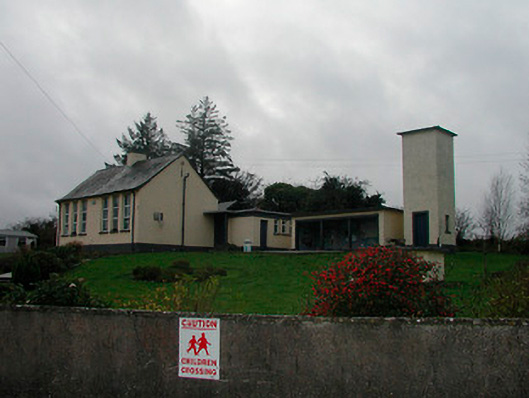
Detached six-bay double-height national school, dated 1953, with single-bay single-storey flat-roofed recessed flanking entrance/toilet/cloakroom blocks to either end (north and south). Three-bay single-storey flat-roofed playshed and two-storey water tower (on square plan) to the northwest. Hipped natural slate roof with (slightly) sprocketed eaves having clay ridge tiles, central rendered chimneystack and cast-iron rainwater goods. Flat-roofs to entrance/toilet blocks with timber eaves. Roughcast rendered walls over smooth rendered plinth. Cut-limestone date stone/plaque to centre of main façade (east). Grouped (two sets of three arrangement) square-headed window openings with concrete sills and replacement windows (originally three-over-three pane timber sliding sash windows with horizontal glazing bars). Square-headed door openings on two concrete steps with projecting splayed reveals supporting concrete canopy having timber panelled doors. Set back from road in own grounds having tarmac yard to front east. Bounded to road-frontage by rendered boundary wall having rendered gate piers, iron double gates and rendered stiles.
A typical mid twentieth-century national school, which retains its early character and plan. The building has witnessed some alteration in the form of uPVC windows, but its original form is still intact. National schools of this type were built in large numbers in rural Ireland to a standard design prepared by the Board or Office of Public Works. The standard plan accommodated a pair of classrooms with associated services ranges in a wholly-integrated symmetrically-planned unit. Rural schools of this type frequently have\had associated playsheds and water towers as found here at Cartron, which helps to add importance to this particular example. Having been well-maintained the school presents an original aspect, thereby contributing positively to the character of the locality. The boundary walls with entrance stiles completes this composition.
This does not grant access. Most recorded buildings are privately owned; view them only from public ground unless the owner allows entry.
Places near here
 gates/railings/wallsgates/railings/walls · 92 yd
 Kildallan Bridgebridge · 251 yd
 Enclosure in Sonna DemesneEnclosure · 837 yd
 OutlinedFairy fort / earthen ringfort · 1.1 mi
 Simonstown Castle (in Ruins)Castle, unclassified · 1.3 mi
 Site of CastleCastle, unclassified · 1.5 mi
 WestmeathVisitor information · 1.8 mi
 Ancient Ring FortWood · 2.7 mi
 Baronstown ForestWood · 3.2 mi
 Carrickphilbin IslandIslet · 3.2 mi
 Srudarra IslandIslet · 3.8 mi
 Abbeyshrule AbbeyRuins · 7.4 mi
Other information
Photo: National Inventory of Architectural Heritage · Website use allowed for educational or private purposes with source credit