What is recorded here
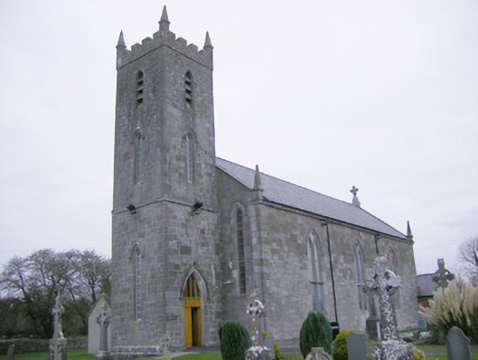
Freestanding Roman Catholic church, built between 1845-46, having three-bay nave elevations, three-stage square-plan entrance tower to west elevation and sacristy to south. Pitched artificial slate roof having cut limestone eaves course and limestone copings, cross finial and pinnacles to corners. Corner pinnacles and crenellations to tower. Snecked limestone walls with tooled limestone quoins, cut limestone stringcourse to first stage of tower. Pointed arch openings to nave with carved limestone hoodmouldings, Y-tracery and stained glass. Pointed arch opening to east elevation with intersecting limestone tracery, carved limestone hoodmoulding with carved limestone stops depicting faces. Lancet openings to first floor of tower and pointed arch louvered openings to second stage. Pointed arch opening with timber panelled door having panelled overlight and carved limestone hoodmoulding. Scissor-brace timber roof to interior, marble reredos to altar, timber gallery to rear. Square-profile limestone gate piers with pointed caps to front of site flanking wrought-iron gates.
This church has been successful in retaining both its original form and many of its original features. The finely carved tracery and stained glass to the windows and carved stops add both visual appeal and artistic value to the church. Such work along with the varied stone finishes is testament to the skills of quality craftsmanship of the late nineteenth century. Located at a T-junction it is an important part of the historic fabric of the small nucleated settlement of Meanus.
This does not grant access. Most recorded buildings are privately owned; view them only from public ground unless the owner allows entry.
Places near here
 Green Lawnhouse · 314 yd
 Concentric enclosure in BoherygeelaConcentric enclosure · 898 yd
 Gray's Bridgebridge · 933 yd
 KillorathBurial ground · 1048 yd
 Glenogra Castle (in ruins)Castle, Anglo-Norman masonry castle · 1.1 mi
 Bawn in Rathmore NorthBawn · 1.5 mi
 Monasteranenagh AbbeyHeritage attraction · 2.3 mi
 Lough GurVisitor information · 2.7 mi
 Skool HillMountain / peak · 3.7 mi
 Villiers WellSpring · 4.1 mi
 European ashEuropean ash · 4.2 mi
 Biodiversity in the Maigue CatchmentVisitor information · 4.7 mi
Other information
Photo: National Inventory of Architectural Heritage · Website use allowed for educational or private purposes with source credit