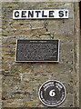
What is recorded here
This black commemorative plaque records: Gentle Street. Paved in its entirety with stone setts and once a major entry, goes back to the origins of Frome in the 7th century. Here St. Aldhelm trod and the Saxons had a look-out. Mediaeval men called it Hunger Lane because of its steepness. Later the Gentle family gave their name to it and the London coach left from the Waggon & Horses Yard. This plaque is given by the Frome Society for Local Study to commemorate the repaving of this historic way by Somerset County Council in 1987. The contractors were Winterbourne Excavations Ltd., of Bristol, and the mason Brian Mahon, assisted by Michael O'Loughlin. Recorded plaque organisation: Frome Society for Local Study.
Gentle Street, dating back to the 7th century, has historical significance for its connection to St. Aldhelm and its role as a major entryway in Frome, reflecting the town's medieval heritage and evolution over centuries.
A plaque record does not grant entry to a building or private land. View it from a public place unless permission is clearly given.
Places near here
 Lamp Post on Steps to North of Church of St John the BaptistListed building · 9 yd
.jpg?width=1280) War Memorial in the church forecourtListed building · 42 yd
War Memorial in the church forecourtListed building · 42 yd St Aldhelm Well, FromeOld or holy well · 49 yd
 Statue of Nancy GuyMonument or public art · 183 yd
 Frome MuseumMuseum · 270 yd
 Old Milestone Plates, Frome MuseumMonument or public art · 357 yd
 Orchardleigh WoodForest or wood · 2.2 mi
 Bonnyleigh HillMountain or hill · 2.3 mi
 Cheese Hill Lay-byMountain or hill · 2.3 mi
 Beckington CastleCastle · 2.6 mi
 Byfields CemeteryChurch, cross or graveyard · 2.8 mi
 Nunney CastleScheduled monument · 2.8 mi
Other information
Photo: Neil Owen on Geograph · CC BY-SA 2.0